

We have fully switched to all snow across western Iowa and eastern Nebraska as of the early afternoon. Heavy pockets of snow will move through at times, causing near whiteout conditions with the help of 50-65 mph winds. If you have the option to stay home today, please stay home today! The worst combination of heavier snow and strongest wind will continue into the middle of the afternoon in Omaha. The snow will then start to lighten up later in the afternoon as it moves east. By the evening commute, neighborhoods west of the metro should be done with snow, but Omaha and east will still have some snow falling. The Omaha metro likely sees an end to the snow around 6 or 7 p.m., followed by all of western Iowa around 8 or 9 tonight.
Today's strong wind could cause a few power outages before it starts to lighten up tonight. After the snow ends, it likely won't blow around much since it will be heavy, wet snow. The relatively warm weather will also help road crews make fast progress on the roads once the snow ends.
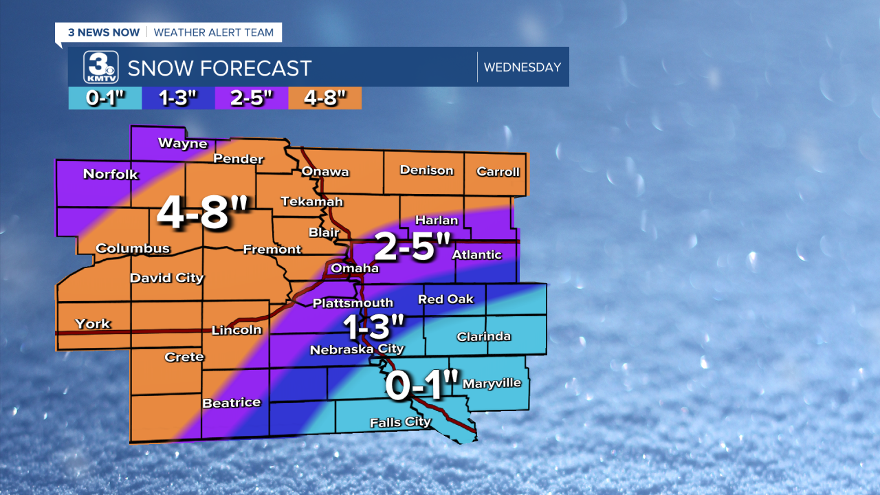
Temperatures will likely be near or above freezing most of the day, but the snow will be falling fast enough to overcome the melting from the warm ground and air. The highest totals will be north and west of downtown Omaha with 4-8 inches, including the western half of Douglas County. Where heavier pockets of snow have been stubborn, some of those spots will go even higher. For downtown Omaha and Council Bluffs, we're still expecting 2-5 inches. As you head farther southeast, totals will drop quickly, but these areas will still have low visibility as the snow falls. See map for your neighborhood.
Although the wind lightens up overnight, it could still be a bit breezy Thursday morning as spring officially begins! The wind will be lighter the rest of the day. Highs will be near 50 with mostly sunny skies.
Friday will be mostly cloudy and windy, but warmer, with highs in the mid 50s. There could be a couple spotty and light showers around late in the day, but most of us will stay dry.
We get a little more sunshine Saturday with low 60s. Sunday looks mostly cloudy with upper 50s. Like Friday, there could be a couple spotty pockets of light rain around over the weekend, but most of us stay dry.
Monday will also be in the upper 50s with partly cloudy skies.
Tuesday looks a touch warmer with low 60s.
WEDNESDAY
Cloudy
Snow
Very Windy
High: 37
WEDNESDAY NIGHT
Clearing Skies
Windy Early
Low: 20
THURSDAY
Mostly Sunny
Spring Begins
High: 50
FRIDAY
Mostly Cloudy
Windy
Spotty Rain
High: 56
Share your weather pictures with KMTV:
- Email to News@3newsnow.com
- 3 News Now Facebook page
- Use the hashtag #3NewsNow on Instagram or X (formerly Twitter)
