

As of the lunch hour, scattered snow, sleet, and a little freezing rain is moving northeast through the area. This will continue for a couple hours in western Iowa before we dry out from west to east. The wind has also been picking up, and will reach speeds up to 40 and 50 mph at times, which could blow the recent snow around, lowering visibility and pushing it back onto cleared roads. Luckily, this wind is out of the south, which will help warm us up into the low 30s this afternoon.
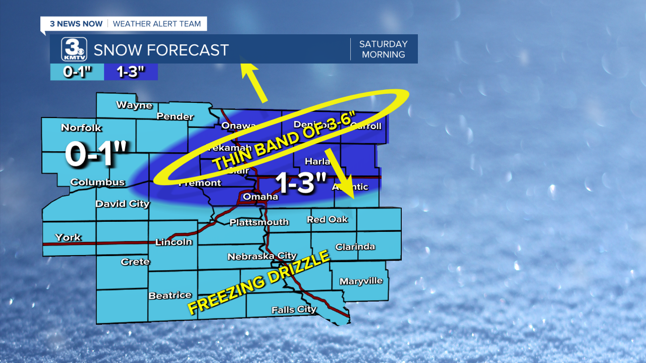
Late tonight, scattered snow will start to move back in, which could include pockets of freezing rain again. Overnight, some of the heaviest snow could form into a thin line stretching from southwest to northeast and sit over the same area for multiple hours into Saturday morning. While the rest of us see lighter snow, neighborhoods under the heavy band of snow could see up to half a foot of snow. The problem is, even just hours away, we can't say exactly how far north or south that thin line of heavy snow is going to be. Smaller snow totals will be much more common. Outside the heavier snow band, totals west and south of Omaha will likely be 0-1 inch. The Omaha metro and areas northeast have a better chance of seeing totals push into the 1-3" range. Hopefully, we'll get a better idea of where the heavier snow will set up tonight, but for now, it's a wait and see.
While snow will still be common Saturday morning, it begins moving out into the lunch hour and ends in the afternoon. Like Friday, a little freezing rain could mix into the snow in a few spots, especially south of Omaha. The rest of Saturday will be mostly cloudy and windy. After starting the day in the mid 20s, we will drop into the low 20s for the afternoon.
It will still be windy early Sunday, but the wind should lighten up for the afternoon. It keeps getting colder. Highs will only be near 10 with a mix of sun and clouds.
Another round of snow starts to move in Monday morning with widespread snow continuing through the afternoon. A lot of us will get a break from the snow heading into Monday night, but more snow will likely fall south of Omaha on Tuesday. This will put the highest totals south of Omaha, but we could easily pick up a couple more inches of snow in the metro early next week. Snow totals will be lower the farther north you live.
Along with the snow early next week, brutally cold weather settles in. Monday will start below zero and only warms into the upper single digits in the afternoon.
Tuesday looks to be the worst of the upcoming cold. We start near -10 and barely get above zero in the afternoon.
We'll see a little more sunshine Wednesday, but highs will stay in the single digits.
Thursday starts well below zero too, but we could hit the double digits above zero in the afternoon.
We should see temperatures get back to average, or even above average, over the following weekend.
FRIDAY
Mostly Cloudy
Scattered Wintry Mix
Very Windy
High: 32
FRIDAY NIGHT
Mostly Cloudy
Scattered Snow
Windy
Morning: 26
SATURDAY
Mostly Cloudy
Scattered Snow &
Freezing Rain
Windy
Afternoon: 21
SUNDAY
Partly Cloudy
Windy Early
High: 10
Share your weather pictures with KMTV:
- Email to News@3newsnow.com
- 3 News Now Facebook page
- Use the hashtag #3NewsNow on Instagram or X (formerly Twitter)
Download the free Storm Shield app for iOS and Android phones
Receive severe weather watches and warnings for your location as you track the storms on radar. Great for use at the office, at home, and while traveling.
