Living in the Midwest, we are used to the wild weather that can come each year. Yet, 2024 was one of the most active years in Omaha weather in quite some time. The only year that compares is 1975 when Omaha experienced a historic blizzard and an F-4 tornado. 2024 brought snowstorms, tornado outbreaks, windstorms, flooding, hail, drought, and more. One could describe 2024 as the "year of everything" for Omaha's weather.
First, let's look at the year as a whole. Broadly, 2024 was a very warm year for Omaha. Our average temperature throughout the year is around 54.5°, the 6th warmest year on record (records date back to 1871). If you take the average of our high temperatures this year, it adds up to 65.8°, the 2nd highest on record. Our low-temperature average is a bit less impressive, only ranking 18th warmest.
In terms of precipitation, we landed right around average. Our average precipitation in Omaha is 31.86", and we ended this year with 32.94". The year was marked with very wet spells (i.e. May) and long dry spells (i.e. September).
For snowfall, 2024 was lacking. Omaha received 16.4" of snow, well below our average of about 25". This has continued our streak of snowless years, 2022 and 2023 were also well below average in the snow department. Yet, we still saw snowstorms, which leads us to how 2024 began...
JANUARY 8-20
SNOW, MORE SNOW, THEN BRUTAL COLD
We hardly went two weeks in 2024 without experiencing our first major event. The Omaha region experienced two big snowstorms, followed by truly arctic air. On January 8, the first big snowstorm hit. Snow totals in Omaha were tampered some by warm ground temps, but 3-6" still fell. In other sections of eastern Nebraska, as much as a foot of snow fell in some locations.

Three days later, a second big snowstorm brought more snow. Between 8-11" of powdery snow fell and was blown around by 35-45 mph winds, creating blizzard-like conditions for our area.

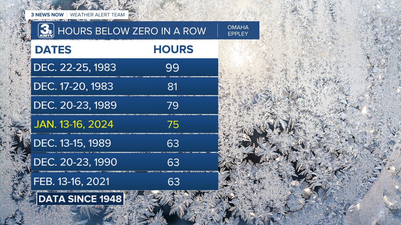
Once the snow settled, Omaha braced for one of the longest cold snaps in recent memory. For 75 hours, the temperature at Eppley Airfield sat below 0, the 4th longest stretch since the airport began recording data in 1948. The brutal cold prevented the snow from melting, leaving many streets snow-covered for the next week.
Finally, to end the active January, a snow squall pressed through Omaha on the 18th, dropping another 2.3". This was one of the first instances of a "Snow Squall Warning" issued by the National Weather Service.

Overall, mid-January 2024 brought back a true taste of what winter can be like in Nebraska and Iowa. For more information on these, you can read the blog posts on the January 8, January 12, and January 18 snowstorms.
FEBRUARY
FROM 80° TO 8° IN 36 HOURS
After enduring January, February flipped the script and suddenly, winter was gone. Omaha experienced the third warmest February on record, we hit at least 60 degrees 9 times! Our February was so warm, it was not too far off from the average March. It was also very dry, with only 0.8" of snow recorded during the month, the 6th driest on record.

Then came February 26th, when Omaha, for the first time in recorded history, hit 80 degrees in February! We then saw temperatures drop the following day when at 4 pm on the 27th we were in the 20s! This constituted one of the largest temperature drops in Omaha history, going from 80 degrees on Monday afternoon, to 8 degrees by Wednesday morning!
APRIL 16
THE FIRST OF MANY TORNADOES
Severe weather season began in earnest on April 16, when the first of many tornadoes occurred. Two waves of storms moved through. The first was in the morning, bringing 4 tornadoes to northwest Missouri and southwest Iowa. By the afternoon, storms erupted over northeast Nebraska, where numerous funnel clouds and small tornadoes happened. Four tornadoes occurred over Platte and Colfax Counties. Luckily, nobody was hurt or killed by these tornadoes. More information can be found here.
APRIL 26
ARBOR DAY TORNADO OUTBREAK
Perhaps the defining weather event of 2024, the worst tornado outbreak to impact eastern Nebraska and western Iowa since the Easter Sunday tornado outbreak of 1913. 24 tornadoes, many strong to violent, impacted communities in and around the Omaha metro.

The more notable tornadoes included the EF-3 that began in northeast Lincoln and moved near Waverly, striking an industrial building and destroying it. The EF-4 that slashed through neighborhoods in Elkhorn, Bennington, and Washington County. An EF-3 that began in Council Bluffs, hit Eppley Airfield and passed south of Crescent. Then another EF-3 between McClelland and Treynor in Pottawattamie County. Finally, a large EF-3 devastated Minden and narrowly missed Harlan in Iowa.
These, among many others, destroyed homes and uprooted lives. One person was killed in Minden, and several were injured in Elkhorn. For more information on this outbreak, you can find it here.
MAY 6
DEJA VU FOR MINDEN
Just two weeks after the devastating Minden tornado, another tornado missed the town by a couple of miles to the east. On May 6, a squall line produced three EF-1 tornadoes in western Iowa. One of these hit homes east of Minden crossed I-80 near Shelby and dissipated south of Tennant. Although no one was hurt or killed, it certainly brought panic back into a region so recently affected. More information can be found here.
MAY 10-11
THE NORTHERN LIGHTS
2024 was also a brilliant year for astronomical events. On April 8, the US was graced with the total solar eclipse that millions witnessed. Although totality missed Nebraska and Iowa, we still witnessed the dimming of the sky as the moon passed over the sun.
What Nebraska and Iowa got to witness in its full glory was the northern lights on the night of May 10-11. A powerful geomagnetic storm crashed into Earth, bringing the northern lights to be visible as far south as the Gulf Coast! The lights were so bright in Nebraska and Iowa that they pulsated overhead, and even those in the urban core of Omaha could catch a glimpse of this phenomenon.

The northern lights returned on the evening of October 10, when bright red columns appeared over the sky in Nebraska and Iowa.
MAY 21
MAJOR FLOODING AND TORNADOES
Severe weather returned with a vengeance on May 21, when several rounds of tornadic storms caused major problems in the Omaha area. In the morning, a line of severe storms brought several weak tornadoes to the area and dumped 4-6" of rain in the Omaha metro. The flash flooding was significant, with Papio Creek rising out of its banks in several locations. Several water rescues occurred around the area, and the AM commute was slow as motorists avoided flooded-out streets. You can see the timeline of the floodinghere.
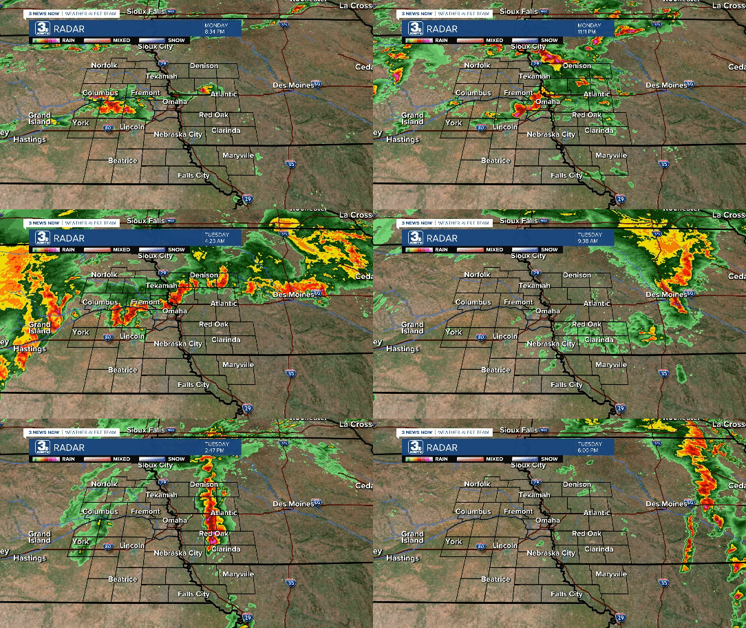
Sirens blared again over Omaha by lunchtime as another round of tornadic storms passed. A weak tornado struck Yutan in Saunders County, but the bigger show was over southwest Iowa. An EF-1 tornado hit the west side of Red Oak. Then an EF-3 passed near Villisca and Carbon. Finally, an EF-4 tornado began in far northeast Page County, continued through Adams County, and slammed into the south side of Greenfield.

Packing winds of 185 mph, the Greenfield EF-4 was the strongest tornado of 2024. Homes were destroyed, cars tossed, and trees mangled. More information on this tornado outbreak can be found here.
MAY 24
ANOTHER ROUND OF TORNADOES
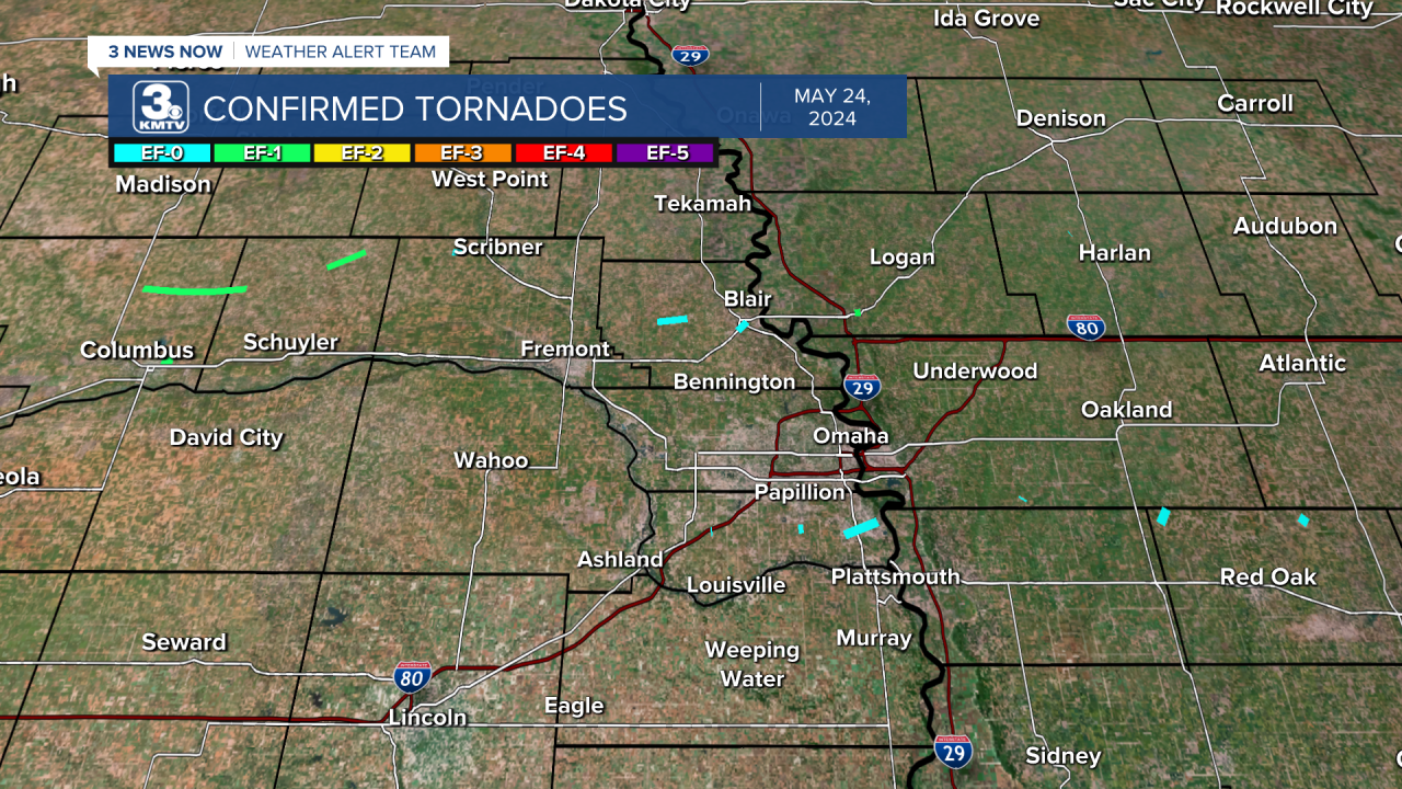
The region hardly had time to catch its breath before yet another tornado outbreak struck. On the morning of May 24, a line of severe storms brought widespread damaging winds of 60-70 mph to the area. Alongside those winds were 17 tornadoes. A few of these tornadoes impacted communities. Blair was hit by an EF-0, Missouri Valley by an EF-1, and the Shadow Lake neighborhood of Papillion saw a tornado, as did Bellevue with damage done at Offutt AFB & Old Towne.
A final burst of severe weather came in the late evening of May 25, when 60-70 mph winds formed on the backside of departing thunderstorms in Omaha, knocking several thousand out of power for hours.
More information on the May 24 tornadoes and the May 25 wind can be found here and here.
2024
THE DROUGHT IS GONE...THEN RETURNS
Due to our extended wet and dry spells, the drought that has remained with us since 2022 was erased. May was very wet, the 2nd wettest May on record, in fact. This continued into a wet June and continued to erode the drought. By the end of June, eastern Nebraska and western Iowa was drought-free for the first time since the summer of 2022.
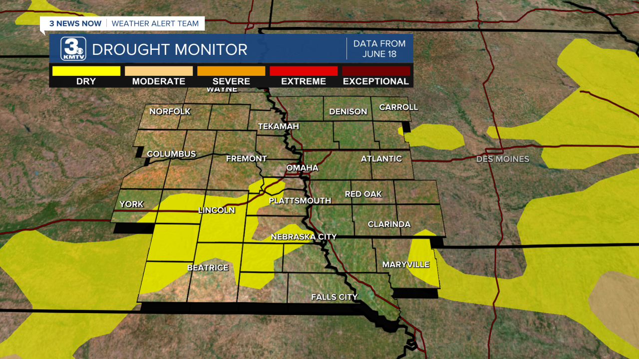
Unfortunately, a dry fall has allowed the drought to redevelop over the area. As of the end of 2024, most of us are in the moderate drought (2/5) category, except northwest MO/southwest IA.

JUNE 12
A ROUGE HAILSTORM
During the hot and humid weather of June 12, two hailstorms erupted over the area. The first one began just south of Sioux City and dove southward along I-29 in western Iowa. Onawa received 3.5" hail, and a brief tornado occurred near Decatur.

As this storm continued, a second storm developed over Washington County and dove southward through the Omaha metro. A narrow strip of 2-2.5" hail fell from Blair to Cunningham Lake to Hanscom Park to Bellevue. Cars had windows broken, skylights were cracked, and the greenhouse at Hanscom Park was destroyed.
LATE JUNE
THE MIGHTY MO FLOODS
Due to very heavy rains over Siouxland, all that water flowed into the Missouri River to create major flooding by the end of June. Floodwaters reached some of the highest crests in history, falling below 2011 and 1952 levels. Many farms and other structures along the river flooded, and I-29 was closed in Pottawattamie County for a time as the water flowed over it. For details on how high the river got and how fast it was flowing, you can read about it here and here.
JUNE 25
BIG HAIL, THEN BIG WIND
Amid the Missouri River flooding, another bout of severe weather impacted the Omaha metro. It was a one-two punch of giant hail and high winds. In the evening, a hailstorm developed over downtown Omaha and drifted south into Sarpy County. 2-4" hail fell across Papillion, La Vista, and Bellevue. The 4.5" hail (softball size) that fell in Bellevue is tied for the largest hailstone measured in Douglas or Sarpy counties! Damage was done to cars and windows across Sarpy County.

Another storm aimed at the area a few hours later, this time over North Omaha. This storm did not bring hail, but high winds of over 100 mph in North Omaha and Florence. Eppley Airfield measured a 90 mph wind gust, and estimates of over 100 mph winds were common. Hundreds of trees across North Omaha and Florence were snapped, and structural damage was done to buildings.

APRIL-JULY
A RECORD YEAR FOR TORNADOES
Outside of the high-impact tornado outbreaks of April 26, May 21, and May 24, we saw other tornadoes. The aforementioned April 16 tornadoes were the start. Other tornado events occurred on June 15, when several tornadoes hit northeast Nebraska, including an EF-1 that shredded fields north of Clarkson. More tornadoes happened on July 1, including an EF-1 that hit the Rokeby area south of Lincoln.

Overall, 2024 has recorded 86 tornadoes in our viewing area alone, the most in any year by far (the 2nd highest is 2008 with 46 tornadoes). On average, our viewing area sees 16 tornadoes in a given year. In Nebraska, 102 tornadoes have been confirmed, the third highest since 2004 with 111 tornadoes and 1999. In Iowa, 127 tornadoes have happened, the highest in any given year.
JULY 31
THE BIG LINCOLN-OMAHA WINDSTORM
The severe weather season could not have ended worse than the high windstorm on July 31. That evening, a windstorm packing winds 80-100 mph ripped through the Lincoln and Omaha metro areas. Thousands of trees were damaged or destroyed, cars were crushed, and homes were damaged. The Lincoln Airport recorded an 83 mph wind gust, while Eppley Airfield recorded a 90 mph wind gust.
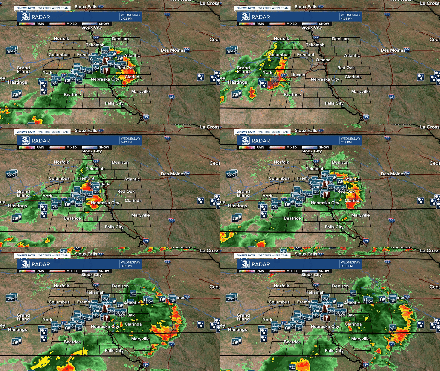
At its peak, tens of thousands were knocked out of power in Lincoln, the third-largest outage in LES history. In Omaha, over 200k were without power, the largest outage in OPPD history. Some neighbors were without power for up to 7 days! The damage was immense, and it will go down as one of the costliest storms in Omaha's history.
FALL
DRY...THEN WET
Once the wet summer subsided, we got dry for fall, bone dry. September saw only 0.08" of rain, making it the driest September on record. In October, it did not rain for nearly the entire month! It wasn't until the final few days that rain returned to the area.
Then the switch flipped for November, and we saw several big rain events. It was the third wettest November on record for Omaha. Then, we entered another dry pattern from November into early December.
This dry pattern has allowed for the drought to return.
DECEMBER 13
A NIGHT OF ICE
As December rolled around, 2024 had one last surprise in its sleeve, an ice storm. On Friday, December 13, freezing rain developed across the viewing area leading to a glaze of ice. Despite ice accumulation being light, it caused major problems across the area.

Hundreds of slide-offs and stalled vehicles were reported, crashes were common, and roads were impassable. I-80 was closed in Sarpy County for a time. Tragically, one driver was killed in Washington County due to an accident.


