
On the night of July 1 into July 2, several rounds of heavy rain moved across eastern Nebraska and western Iowa. While most of us picked up on some rain, there was a corridor of very heavy rainfall amounts from Seward to Sarpy County to Des Moines. In this band, some locations received over 6" of rain, leading to significant flooding. One of the hardest hit areas was South Bend in Cass County, where a Flash Flood Emergency was issued for homes that were flooded.
The storms also brought two tornadoes to southeast Nebraska. One occurred in Saline County, the other on the outskirts of Lincoln.
Here are the a select number of rainfall totals from the viewing area:
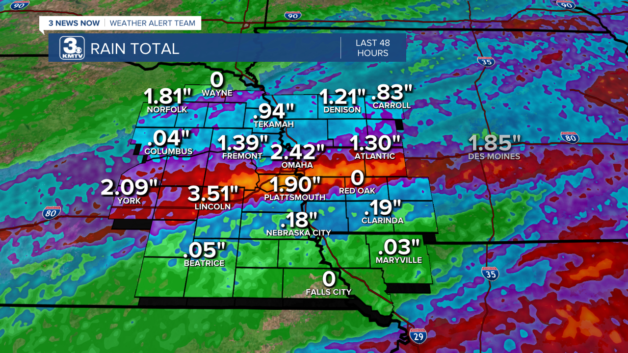
Ashland (Saunders, NE) - 8.29"
Davey (Lancaster, NE) - 7.53"
Bellevue (Sarpy, NE) - 7.27"
Raymond (Lancaster, NE) - 6.29"
Papillion (Sarpy, NE) - 6.24"
Malcolm (Lancaster, NE) - 6.26"
Pacific Junction (Mills IA) - 6.10"
Gretna (Sarpy, NE) - 6.00"
Springfield (Sarpy, NE) - 5.96"
La Vista (Sarpy, NE) - 5.91"
Louisville (Cass, NE) - 5.80"
Waverly (Lancaster, NE) - 5.46"
Plattsmouth (Cass, NE) - 4.86"
Wahoo (Saunders, NE) - 4.20"
Milford (Seward, NE) - 4.16"
Millard (Douglas, NE) - 4.05"
Seward (Seward, NE) - 4.00"
Brainard (Butler, NE) - 3.70"
Council Bluffs (Pott., IA) - 3.67"
Carter Lake (Pott., IA) - 3.56"
Boys Town (Douglas, NE) - 2.84"
Fremont (Dodge, NE) - 2.83"
Elkhorn (Douglas, NE) - 2.60"
Bennington (Douglas, NE) - 2.58"
David City (Butler, NE) - 2.44"
Blair (Washington, NE) - 2.22"
Stanton (Stanton, NE) - 2.12"
Wayne (Wayne, NE) - 1.89"
Norfolk (Madison, NE) - 1.88"
West Point (Cuming, NE) - 1.35"
Missouri Valley (Harrison, IA) - 1.32"
Columbus (Platte, NE) - 1.17"
Onawa (Monona, IA) - 1.01"
Clarkson (Colfax, NE) - 0.96"
Tekamah (Burt, NE) - 0.78"
Shenandoah (Fremont, IA) - 0.50"
Sidney (Fremont, IA) - 0.43"
Alongside the rain, two tornadoes were spawned from the storms. One occurred over Saline County, the other just southwest of Lincoln. Here is the breakdown on the tornadoes:
DORCHESTER, NE
Rating: EF-0
County: Saline
Max. Wind Speed: 74 mph
Path Length: 0.26 mi
Tornado Width: 80 yards
Overview: A brief tornado snapped several trees southwest of Dorchester along Highway 15. No other damage was noted.
ROKEBY, NE
Rating: EF-1
County: Lancaster
Max. Wind Speed: 107 mph
Path Length: 2.28 mi
Tornado Width: 300 yards
Overview: Began near SW 27th Street and W Rokeby Road on the outskirts of Lincoln. The tornado caused damage to a horse facility was damaged with 6 stables destroyed. The tornado followed Rokeby Road damaging more outbuildings and acreages before lifting near S 1st St and Rokeby Road, just west of US-77.
