
Over the past 48 hours, multiple rounds of rain occurred from northern Nebraska into southeast South Dakota, northwest Iowa, and southern Minnesota. In some locations, up to 10-15" of rain fell. Last night, another round of heavy rain brought destructive flooding to communities like Spencer and Rock Valley in northwest Iowa.
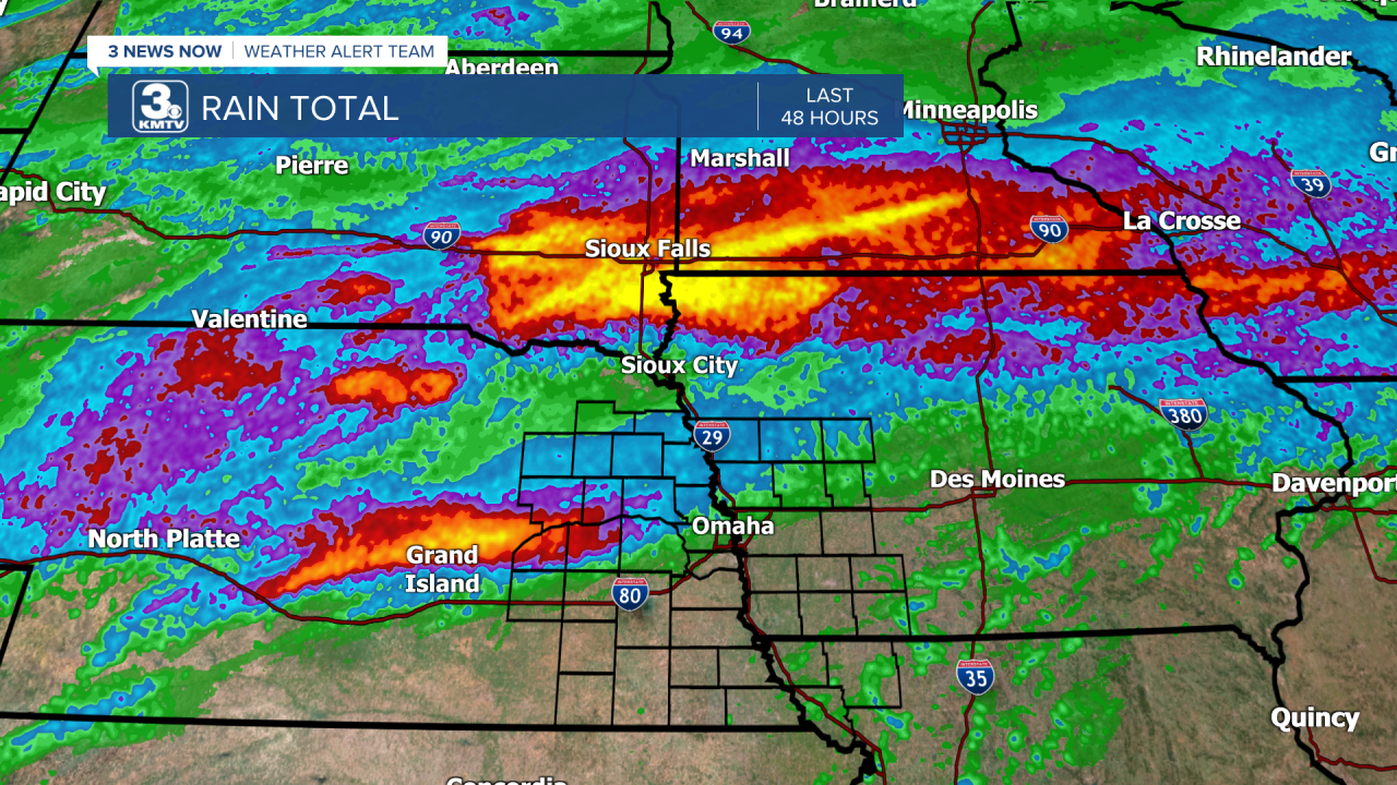
All that water has to go somewhere, and over the next several days it will flow into the Missouri River. This will bring the likelihood of minor to moderate flooding to the Missouri River basin in eastern Nebraska and western Iowa beginning next week. Many locations along the river are expected to see minor to moderate flooding.
Friday night also saw a band of heavy rain that fell in central Nebraska near the Platte and Loup River Basins. Although the rivers will rise, there is NO river flooding expected from the Platte, Elkhorn, or Loup Rivers. This will be a Missouri River event.
Below are the latest forecasts and expected impacts from the flooding next week. Broadly, flooding is expected to begin early next week, crest by late week, then recede by the weekend into early next week.

DECATUR
Current Level: 25.03'
Flood Stage: 35'
Expected Crest: 35.8'
Flood Stage: MINOR
Begin Time: Tuesday PM
Crest Time: Wednesday
Impacts: Low-lying areas are flooded. Marinas and boat docks flood.
BLAIR
Current Level: 20.02'
Flood Stage: 26.5'
Expected Crest: 29.1'
Flood Stage: MODERATE
Begin Time: Tuesday AM
Crest Time: Thursday
Impacts: Flooding could impact I-29 between exit 61 near Crescent and exit 71 near Loveland, as well as the I-680 ramp near Crescent. Several campgrounds are flooded. County Roads 34, 37, and 51 are flooded out east of Fort Calhoun.
OMAHA
Current Level: 20.69'
Flood Stage: 27'
Expected Crest: 31.8'
Flood Stage: MINOR
Begin Time: Tuesday AM
Crest Time: Friday
Impacts: Flooding is expected in NP Dodge Park, Freedom Park, Tom Hanafan Park, Fontanelle Forest, and Halworth Park. Council Bluffs closes all flood gates. Parts of Lewis and Clark Landing at the Riverfront is closed. No major flooding is expected to structures in Omaha or Council Bluffs.
PLATTSMOUTH
Current Level: 20.82'
Flood Stage: 26'
Expected Crest: 30.02'
Flood Stage: MODERATE
Begin Time: Tuesday AM
Crest Time: Friday
Impacts: Flooding is expected to impact the boat ramp and gauge site, as well as a private campground 1.5 miles north of Plattsmouth. The Water Treatment Plant road floods as well, but the Water Treatment Plant is not expected to flood.
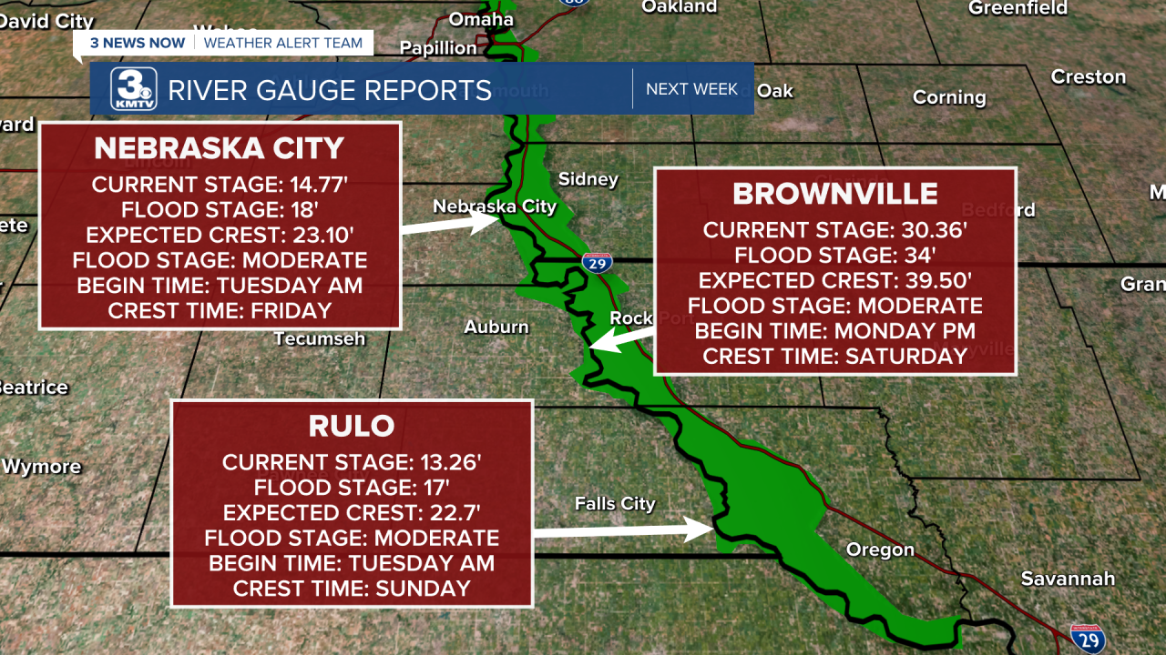
NEBRASKA CITY
Current Level: 14.77'
Flood Stage: 18'
Expected Crest: 23.10'
Flood Stage: MODERATE
Begin Time: Tuesday AM
Crest Time: Friday
Impacts: Low-lying areas around the river flood. Areas along North First Street in Nebraska City floods. Flooding is not expected to impact Highway 2.
BROWNVILLE
Current Level: 30.36'
Flood Stage: 34'
Expected Crest: 39.5'
Flood Stage: MODERATE
Begin Time: Monday PM
Crest Time: Saturday
Impacts: Lowlands flood, impacting agriculture. The parking lot and boat ramp south of US-136 floods, as well as the access road to the power plant and 648A Avenue.
RULO
Current Stage: 13.26'
Flood Stage: 17'
Expected Crest: 22.7'
Flood Stage: MODERATE
Begin Time: Tuesday AM
Crest Time: Sunday
Impacts: Agricultural lowlands flood. Several riverfront cabins flood, as well as the boat ramp in Rulo. Flooding is not expected to impact US-159.
