

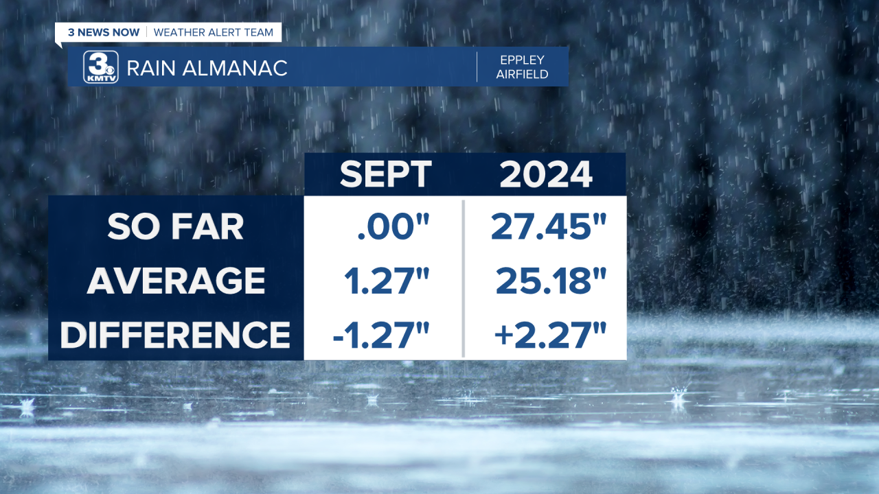
As a whole, 2024 has been a wet month for us. We started with a drier winter, but quickly turned it around in the Spring when we began seeing heavy rain, leading to Omaha experiencing the second wettest May on record. This wetter pattern carried over into the first part of summer with a wet June and July. Then, in August we began to shift into a dry one. This has carried over into September.

It is now two weeks into the month as this article is written, and so far Omaha has picked up no rain. Since 1871, this has only happened 3 times in Omaha that we have seen no rain for the first 14 days of September. Those years were 1882, 1893, and 1908. So this is certainly unusual. On average, we usually pick up about 1.27" of rain through the 13th. Contrast this with September 1-13, 1965, where Omaha picked up over 8" of rain!
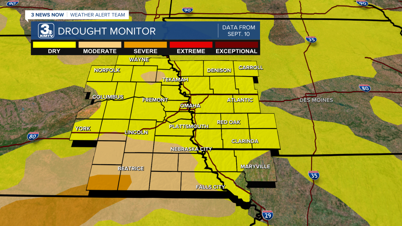
Unfortunately, the lack of rain also causes an increase in drought conditions. If you recall, from the summer of 2022 to June 2024, our region of Nebraska and Iowa was locked into a long-term drought. The wet pattern of spring 2024 broke that drought. Now, the drought is returning. As per the latest drought monitor, almost the entire KMTV region is highlighted in the "abnormally dry" (1/5) category, which is technically NOT drought, but is indicative of an area about to head into drought or recovering from one, we are the former. The "moderate" drought is highlighted over southeast Nebraska and around West Point in Cuming County. The "severe" drought (3/5) category is highlighted in southern Jefferson and southwestern Gage counties.
This might not be wonderful news as we head into harvest season, and our precipitation totals naturally lower. So, what is the outlook for any rain, and changes in the drought over the next few months?
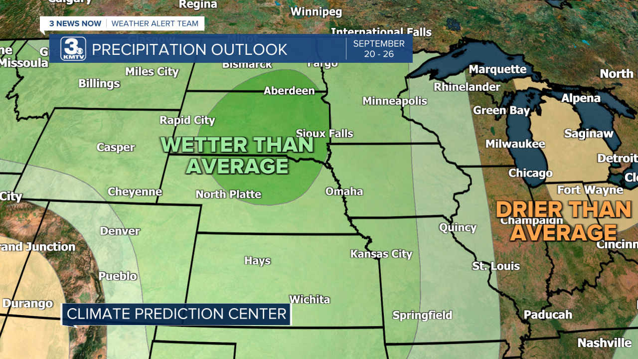
To start, our dry pattern looks to break some by next week. The "blocking" weather pattern with a firm grip over the country will loosen into next week, providing us with some rain chances as early as Monday, but particularly into late next week. This could open the doors for a more active pattern as we head into the back half of September. Who sees rain and how much is still undetermined, but this is a hopeful sign for us!
However, some longer-term trends look for a drier pattern to persist into the fall months of October and November. This does not mean it won't rain the entire time, but rain events may be harder to come by. This has led the Drought Monitor to highlight most of eastern Nebraska where drought is expected to redevelop. It will probably be a slow process, and likely won't be as severe as earlier this year.

Overall, if you're a farmer ready for the harvest, or someone looking to take care of their lawn, this is something to pay attention to as we head into fall. As with all weather, these are forecasts, and they can change. All it takes is a few weeks of good rainfall events to eliminate our drought problem, which could occur even in an overall dry pattern. So for the daily forecast, you can find it on the weather page on this website.
