


Living along a river has many advantages, particularly in the past when the fastest mode of travel was down waterways. However, it can come with its drawbacks. The most significant disadvantage is flooding. Our region's major river is the Missouri River, the longest river in the United States. Every few years, the river swells and causes flooding, but there are those years that define the definition of significant flooding.
Well before our time there was the great flood of 1881, more recently the flood of 1952 brought the river to its highest point in Omaha, then the floods of 1993 also brought significant impacts. Most recently, many remember the flooding along the Missouri River in the summer of 2011. Towns from Montana to Missouri experienced record-breaking flooding, with some of its worst impacts in eastern Nebraska and western Iowa. In this installment of This Week in Weather History, we return to 2011 to look at the time Mighty Mo became too mighty.
WINTER/SPRING 2010-2011
To understand where the floods of 2011 came from, we have to look up north. The origins of the Missouri River are over Montana, so any precipitation in Montana and the mountains flow downstream. For those regions, the winter of 2010-2011 was incredibly snowy, even for the mountains. In fact, many locations saw record snowfall, and it was not even close. Record snowfall fell in Montana and North Dakota. In Glasgow, MT the all-time record winter in terms of snowfall was 70.7" in 2006/2007. In 2010/2011, Glasgow picked up 108.6" of snow! In Williston, North Dakota it was a similar story. The record snowfall was 94.7" from 1895/1896, in 2010/2011 the city received 107.2" of snow.
Due to the colder-than-average temperatures and active weather patterns, the snow continued to pile up through the spring of 2011. By May 1, locations in Montana and Wyoming were over 150% of their average snowpack, much of it refusing to melt during May. Then the rains came.

A slow-moving low-pressure system was blocked by a high-pressure system to the east between May 16-31, bringing repeated rounds of rain and thunderstorms to much of the central United States. For context, the Joplin MO tornado of May 22, 2011, occurred during this system. In Montana and North Dakota, it brought record rainfall. Some cities in eastern Montana received over 10" of rainfall, only 2" shy of yearly rain totals in just two weeks.
To mitigate the disaster of Missouri River flooding, the U.S. Army Corps of Engineers constructed six dams along the Missouri River across Montana and North/South Dakota to help relieve flooding. Where above-average runoff from rain/snow, the dams help to stop the water from pouring downstream. In 2011, the dams met their ultimate test as record amounts of water flowed down the Missouri. Throughout May into August, the barriers managed to help mitigate the floods. If they had not been there, 2011 would have been catastrophic flooding, the likes of which Omaha had never seen before. It still did not mitigate the impacts of 2011 any less, as the floodwaters slowly went down the Missouri.

THE FLOODING: A CHRONOLOGY
Warnings about the oncoming flooding began to ring as early as late April into May, but it was when the wet period in mid-late May began that the alarms were ringing. Up and down the Missouri, people began to prepare for the tide, and as Memorial weekend approached the flood waters began to move down. Eppley Airfield began sandbagging the region, as did towns and cities up and down the Missouri River.
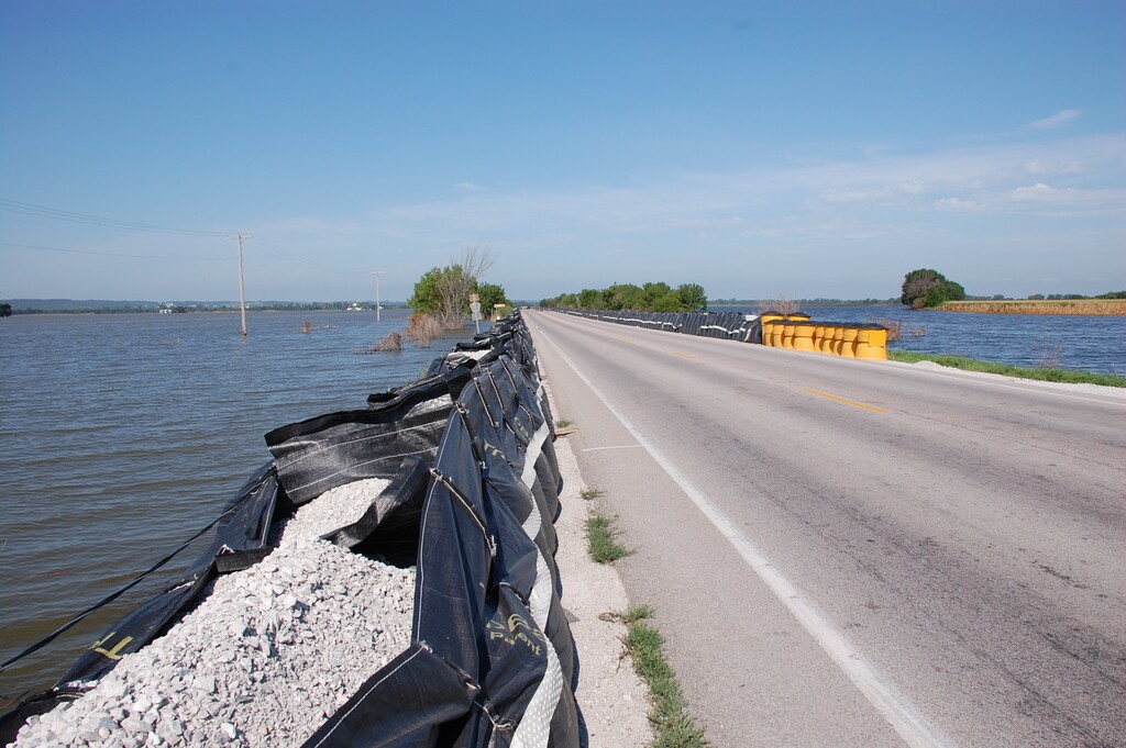
The trouble for the region began June 4, when a levee suffered a partial collapse south of Hamburg, IA in Fremont County. The following day, a second area suffered a partial failure. After a third partial collapse, on June 13 the levee suffered a total collapse as a 300 ft section of the levee failed. Water rushed towards Hamburg, a town of 1100 along the Iowa/Missouri border, forcing 20% of the town to evacuate. For a couple of weeks, the floodwaters remained around Hamburg, on June 27 it began to slop over the emergency levee outside the town, but that held.


The floods forced closures of I-29 in most of western Iowa and several bridge crossings over the river. At certain points, bridges were closed from Sioux City to Omaha, and from Plattsmouth to St. Joseph, MO. Meaning the only location where you could cross the river was at Omaha, even then several bridges were closed. The Bob Kerrey Pedestrian Bridge was closed in late June as floodwaters continued to rage.

In Omaha, the flood won out in some spots, like Freedom Park. At Eppley Airfield, it was a summer-long battle to keep the flooding at bay. Thousands of sandbags were used to keep it away, mostly successful. Eppley managed to remain open for most of the summer with little hindrance from the floods. By July 1, Omaha recorded its second-highest crest ever, along the MO River of 36.29', beating out the flood of 1993 and 2019. Still, number 1 is from the floods of April 1952, with a crest of over 40 feet.

By late June, the flooding intensified across eastern Nebraska and western Iowa. Floodwaters threatened the Fort Calhoun Nuclear Station, but luckily the levees held for the most part, and the nuclear meltdown was avoided. Down south, a similar situation occurred at the Nuclear station near Brownville in Nemaha County.


Levee failures threatened regions in western Iowa. On June 22, residents in Mills County between I-29 and the river were forced to evacuate. On June 25, a levee broke in Harrison County, flooding US 30 between Blair and Missouri Valley, and putting the De Soto Wildlife Refuge under water. Then on July 1, a levee breach near Percival in Fremont County added to woes in Hamburg and the rest of southwest Iowa.

In July, the flooding peaked and held there until August. Attention on the floods turned to northwest MO, where levee breaches continued in Atchison and Holt Counties. On June 21, Craig in Holt County was ordered to evacuate as flood waters crept. The flooding continued all the way to St. Joseph and St. Louis. By September 2011, it was over.

The 2011 Missouri River flooding is considered one of the costliest floods in the Missouri River's history. According to the National Climatic Data Center, the 2011 floods amounted to nearly $2,700,000,000 dollars in damages. It took the lives of several people, including two in Nebraska. Since then, the Missouri River has not experienced nearly anything like that.
