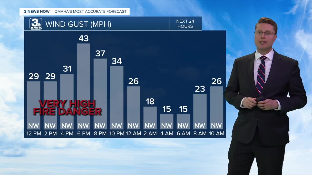

Today will be windy as cooler weather blows in. This will hold us back in the low 60s this afternoon, but we'll see more sunshine as we go later in the day. The combination of dry air and winds up to 45 mph will cause a very high fire danger this afternoon and evening. Hold off on any outdoor burning or anything that could start a fire, because it could spread quickly out of control.
The wind will be lighter tonight, but it will still be breezy at times. An isolated shower is possible northeast of Omaha, but even there, most will stay dry. We'll fall into the mid 30s for Tuesday morning.
Tuesday will be mostly sunny and a little warmer with mid 60s.
It gets a little more breezy again Wednesday as warmer weather moves back in. Highs will be in the mid 70s with a mix of sun and clouds. A few spotty showers will be around eastern Nebraska and western Iowa late Wednesday into Thursday morning, but the rain will miss a lot of our neighborhoods.
Thursday will be warm and breezy with a high near 80! There will be some hit and miss storms in the evening and night. It looks like less than half the area will see rain from the storms, but they could be strong to severe. These should weaken into some leftover spotty rain into Friday morning.
Friday afternoon will be mostly cloudy, breezy, and cooler. Highs will be in the mid 60s, which is average for this time of year.
The wind lightens up for the weekend, and we keep temperatures near average. Saturday will be in the mid 60s with partly cloudy skies.
Easter will also be in the mid 60s with more clouds. There could also be a few scattered pockets of rain, so we'll keep you updated on the weather for your Easter egg hunts.
MONDAY
Clearing Skies
Windy
High: 62
MONDAY NIGHT
Mostly Clear
Breezy
Low: 36
TUESDAY
Mostly Sunny
Lighter Wind
High: 66
WEDNESDAY
Partly Cloudy
Breezy
Spotty Night Rain
High: 74
Share your weather pictures with KMTV:
- Email to News@3newsnow.com
- 3 News Now Facebook page
- Use the hashtag #3NewsNow on Instagram or X (formerly Twitter)
