
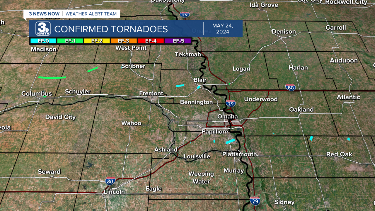
On Friday morning, May 24, a line of severe storms moved across Nebraska and Iowa. They impacted our viewing area between midnight and 4 am, bringing winds up to 80 mph and widespread wind damage. Alongside this wind damage, over a dozen short-lived tornadoes were spawned from this storm system over eastern Nebraska and western Iowa.

TORNADO COUNT
Tornadoes: 17
EF-1: 4
EF-0: 13
TARNOV, NE
Rating: EF-1
Counties: Platte, Colfax
Wind Speed: 107 mph
Time: 1:08 - 1:23 am
Overview: The tornado began east of Tarnov near 385th Street and 250th Avenue. The tornado broadly followed 385th Street through eastern Platte County into far western Colfax County. The tornado damaged storage bins as it crossed over several properties. Outbuildings on a goat farm were damaged at one home. At another farmhouse, many of the buildings suffered damage. The tornado crossed into western Colfax County where the roof of a large livestock barn was damaged.

COLUMBUS, NE
Rating: EF-1
Counties: Platte
Wind Speed: 100 mph
Time: 1:13 am
Overview: A tornado began on the north side of the Columbus Municipal Airport. The tornado was determined in part by the wind speed measured at the Columbus Airport. The winds north of the track were from the NW as the damage showed, while the recorded winds at the airport were from the southwest, suggesting cyclonic rotation. The tornado snapped power poles on 3rd Avenue before lifting near 6th Avenue.
HOWELLS, NE
Rating: EF-1
County: Colfax
Wind Speed: 110 mph
Time: 1:30 - 1:37 am
Overview: This was the strongest tornado from the May 24 storms. It began near Highway 15 and County Road T southwest of Howells, missing the town to the south. The tornado damaged a grain bin, flipped a center pivot early in its life, and snapped power poles as it crossed County Road 14. The tornado at times approached 1/3 mile wide, the widest tornado from the Friday morning storms. The tornado lifted near County Roads 15 and V.
SNYDER, NE
Rating: EF-0
County: Dodge
Wind Speed: 85 mph
Time: 1:50 am
Overview: After 80-100 mph straight-line winds occurred in Snyder, a brief tornado developed just east of town near the Prenzlow Meat Factory, where an outbuilding was destroyed and pine trees snapper. A center-pivot was flipped before the tornado lifted south of Highway 91 between County Roads 8 and 9.

SEWARD, NE
Rating: EF-0
County: Seward
Wind Speed: 70 mph
Time: 1:43 am
Overview: A tornado flipped a center irrigation pivot south of Superior Road about a half mile south of the Seward Municipal Airport. This tornado was very brief, lasting no more than a few seconds.

WOODCLIFF, NE
Rating: EF-0
County: Saunders
Wind Speed: 75 mph
Time: 2:03 am
Overview: A tornado caused some tree and power line damage in the Woodcliff Lake Community. This tornado was very brief, lasting no more than a few seconds.

WASHINGTON COUNTY, NE
Rating: EF-0
County: Washington
Wind Speed: 80 mph
Time: 2:18 - 2:20 am
Overview: One of the longer-lived tornadoes of the event. This tornado followed down on Highway 91 near the intersection of County Road 15 between Blair and Nickerson in central Washington County where trees had some branches snapped off. The tornado snapped more tree branches and a few power poles before lifting near the intersection of County Road P20 and County Road 21.
BLAIR, NE
Rating: EF-0
County: Washington
Wind Speed: 74 mph
Time: 2:22 am
Overview: This tornado began near the Highway 30 roundabout south of Blair. It caused significant tree damage as it moved into town. The tornado lifted near the intersection of South 10th and South Streets in Blair. Straight line wind damage occurred in the rest of town.

MEMPHIS, NE
Rating: EF-0
County: Saunders
Wind Speed: 76 mph
Time: 2:12 am
Overview: Tree and power line damage was caused by a brief tornado along County Road 6 southeast of Memphis. This tornado lasted no more than a few seconds.
GRETNA, NE
Rating: EF-0
County: Sarpy
Wind Speed: 79 mph
Time: 2:25 am
Overview: This tornado snapped several power poles and a few trees on Capehart Road between 180th and 192nd Streets south of Gretna. This tornado lasted no more than a few seconds.

PAPILLION, NE
Rating: EF-0
County: Sarpy
Wind Speed: 79 mph
Time: 2:31 am
Overview: This tornado began over 84th Street and moved into the Shadow Lake neighborhood. Damage was mostly confined to trees and fences, although a few houses near Shadow Lake Elementary School had siding damage.

BELLEVUE, NE
Rating: EF-0
County: Sarpy
Wind Speed: 80 mph
Time: 2:35 - 2:40 am
Overview: The tornado started near Looking Glass Park where a few trees were damaged. The tornado moved over the northern part of Offutt AFB where damage was done to trees, overturning a trailer, and roof damage to a building. The tornado continued northeast into Olde Towne Bellevue where it lifted near the intersection of Franklin Street and Mission Avenue after snapping trees along the path.

MISSOURI VALLEY, IA
Rating: EF-1
County: Harrison
Wind Speed: 107 mph
Time: 2:41 am
Overview: A brief tornado caused lots of tree damage in Missouri Valley. The tornado started near the intersection of 1st and Michigan Streets. The tornado continued down Michigan Street before lifting near St. Clair and 10th Streets. The worst tree damage was noted around 7th and Michigan Streets.

TREYNOR, IA
Rating: EF-0
County: Pottawattamie
Wind Speed: 83 mph
Time: 3:00 am
Overview: This tornado occurred near 300th Avenue and Aspen Street south of Treynor. Three-grain bins were destroyed by the tornado. Other damage occurred to trees. This tornado lasted no more than a few seconds.
HENDERSON, IA
Rating: EF-0
County: Montgomery
Wind Speed: 74 mph
Time: 3:10 am
Overview: Tornado began near the intersection of 120th and A and ended near 100th and B. Damage occurred to several trees and an outbuilding at one farmstead. This tornado lasted no more than a few seconds.
WESTPHALIA, IA
Rating: EF-0
County: Shelby
Wind Speed: 80 mph
Time: 3:13 am
Overview: This tornado occurred near Ironwood Road between Earling and Westphalia. A roof was torn off an outbuilding, and multiple trees lost branches. This tornado lasted no more than a few seconds.
ELLIOTT, IA
Rating: EF-0
County: Montgomery
Wind Speed: 74 mph
Time: 3:22 am
Overview: This brief tornado began at 120th Street and O Avenue. An outbuilding was damaged on one property, and a camper was rolled on another. The tornado lifted at 110th Street.

