


Hail. It is something we in Nebraska and Iowa have to deal with every year, more so than tornadoes. While tornadoes are common from the Rockies to the Atlantic coast, large hail (over 2" in diameter) is largely a Great Plains phenomenon. States such as Nebraska, the Dakotas, Kansas, Oklahoma, and Texas have had some of the largest hail in the nation's history. Nebraska holds the title of the second largest hailstone in the world which fell in Aurora in 2003 at 7.5"! The reason for the large hail seen in the Great Plains is due to the geography, where the combination of warm Gulf air, cold Canadian air, and Desert air come together.
Here in Nebraska and Iowa, hailstorms are relatively common, but only a few produce so widespread damage than what occurred on August 18, 2011. In the span of an afternoon, multiple storms which produced 2+" hail rolled through eastern Nebraska and western Iowa. The hail was so destructive in some parts of western Iowa that you could see the damaged crops on satellite images. In Omaha, the hail struck Eppley Airfield, damaging the facility. In this installment of This Week in Weather History, we look back at one of the more widespread hailstorms our region has seen.
THE SET-UP
The August 18, 2011, meteorological set-up was unconventional for severe weather. There were not any obvious cold fronts or boundaries to spark off storms. So, how did they form? The culprit was likely a boundary that was drifting through the Dakotas. In the early morning of the 18th, an area of showers developed over South Dakota and drifted southeast into the Sioux City metro. Just after lunch, these storms began to intensify and produce severe hail.
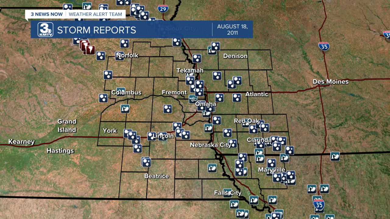
Those storms sent out boundaries of rain-cooled air from the thunderstorms. That boundary soon sparked other storms in eastern Nebraska. The interaction of these storms brought repeated rounds of hail and wind storms to rip through eastern Nebraska, western Iowa, and northwestern Missouri.

TWO STORMS IN THE OMAHA METRO
As those other storms were close to Sioux City, one thunderstorm quickly began to develop near West Point in Cuming County. Within minutes the storm went severe and began producing golf ball size hail (1.75") at Uehling in Dodge County and Craig in Burt County. That storm then turned southeast and moved through Washington County, where hail upwards of tennis ball size (2.50") fell in Herman, Blair, and Fort Calhoun. The storm continued to intensify as it dove southward along the Missouri River. Its next targets were Eppley Airfield, Carter Lake, and Council Bluffs.
Hail first began in Florence, where hail upwards of 3" fell (tea-cup size), many homes were damaged and cars had windshields smashed out. The storm continued onto Eppley Airfield, where some were in planes when the hail that was upwards of softball-size (4.25") fell. The hail was accompanied by wind gusts measured at 62 mph at the weather station.
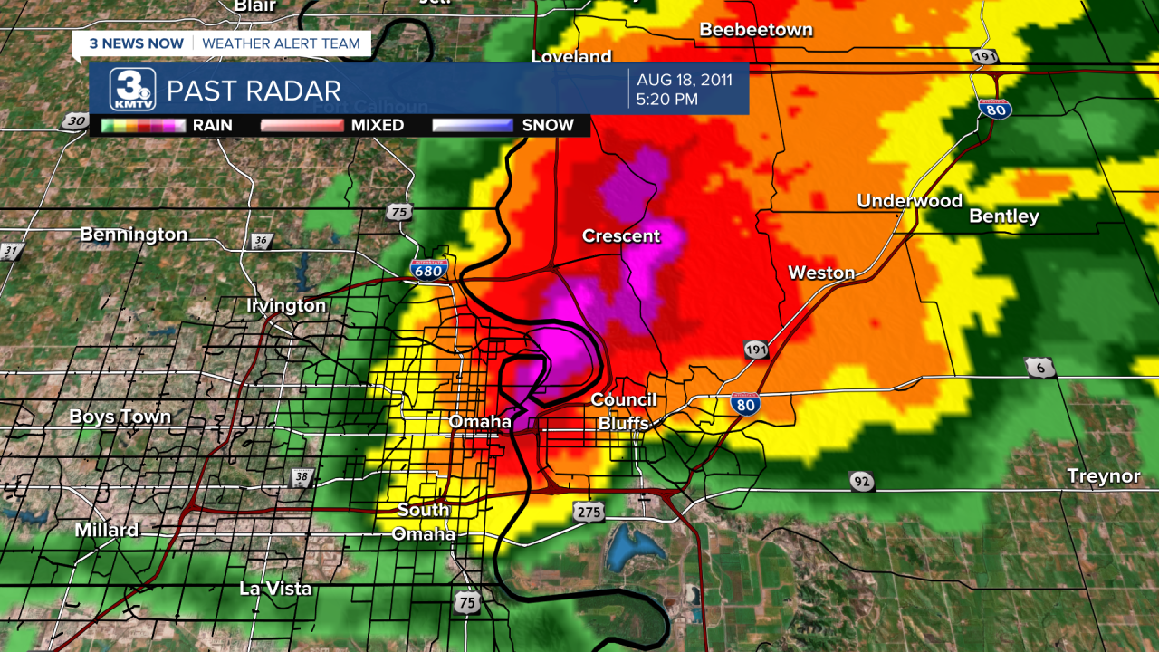
As this video from one of the planes shows, the hail damaged many aspects of the airport. Many cars in the long-term parking lots had their windows smashed in by the hail. A few windows at the airport were cracked, and several commercial planes suffered damage. One pilot of a Southwest Airlines flight was seriously injured and needed to go to the hospital when a softball size stone hit his eye after breaking through the passenger gate/ramp to the plane. The decorative lights that line Abbot Drive towards the Airport were also damaged, with 270 of the 600 lights broken. Around the airport, damage from the storm topped $500,000, and over 1,600 auto insurance claims were filed in Douglas County alone from the hail. West of downtown, hail size decreased drastically, with those west of 60th Street barely witnessing any rain.
Just to the southwest of Eppley, the residents of Carter Lake were stunned watching the chunks of ice falling from the city. Many homes in Carter Lake had their windows busted and siding damaged from the hail.
Across the river, Council Bluffs took a beating. Baseball size hail and 60 mph winds ripped through the town, causing major damage in several sections of the city. The worst damage occurred around Iowa Western Community College, where it was move-in weekend that day. Many new students from out of state got a rude tasting of Iowa weather as many cars lost windows due to the hail. In one row of the parking lot, every car had its windshields smashed in. At least $1,000,000 dollars in damage was done to the college itself to roofing, siding, and windows.

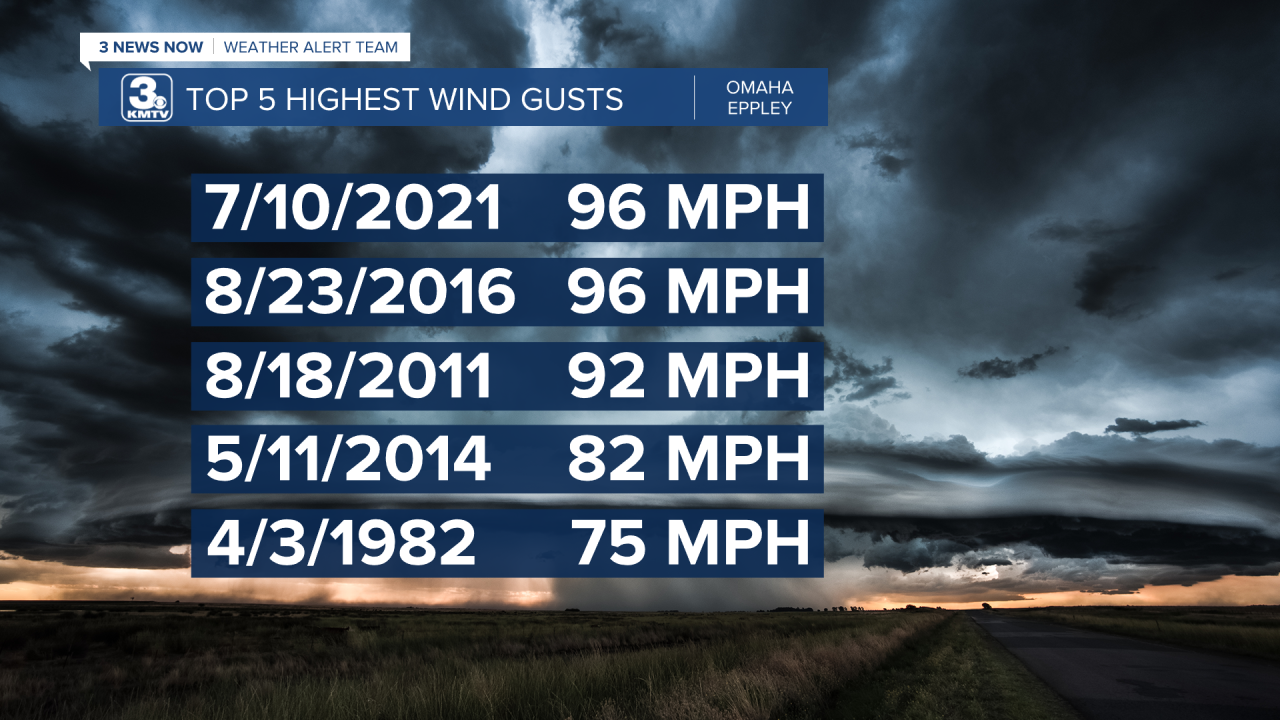
Back at the airport, the facility was temporarily shut down so officials could asses the hail damage. Eppley reopened around 7 p.m., but had to shut down minutes later as a second storm moved through. This storm did not have any large hail, but it did pack some strong winds. The official recording station at Eppley was damaged in the hail, so it was unable to record the winds. However, other measuring equipment at Eppley measured a 92 mph wind gust. That 92 mph wind gust was the second highest wind speed recorded at the airport, but in 3rd place as the top 2 are tied.
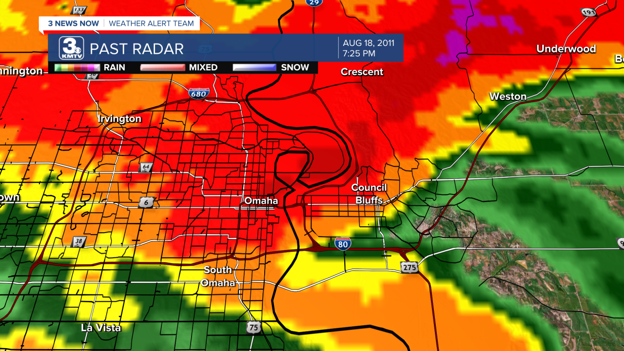
It produced damage across north Omaha as far west as Boys Town, with some trees and power lines down. It also produced heavy rain, drenching cars that had lost windows due to the hail. Over 2" of rain was measured at Eppley Airfield, where the lower-level parking garages saw some localized flooding.
SOUTHWEST IOWA/NORTHWEST MISSOURI DAMAGE
The damage was not localized to the Omaha metro, as these storms continued marching southward into southwest Iowa into northwest Missouri, leading to substantial damage to homes and crops.
The storm that moved over Council Bluffs moved southeastward into Mills County, where damage was widespread. The town of Mineola in the northern part of the county was extremely hard hit. Hail upwards of 4" and winds around 60 mph brought damage to nearly every home in town. On one of the local trails, bikers were caught off guard and suffered minor injuries due to the hail, but recovered quickly. Mineola was one of the hardest hit towns in southwest Iowa, but it was not the only one to do so.
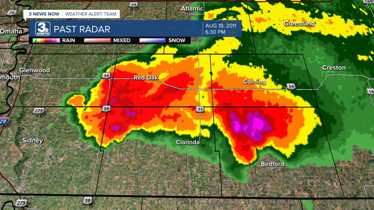
The same storm crossed into Page County it lost its very large hail but still produced hail from 1-1.75" in diameter. This was accompanied by winds upwards of 70 mph as it moved through southern Page County. Cities such as Shambaugh, Coin, and Braddyville suffered extensive damage where many north and west-facing windows were smashed out. The church at Shambaugh had its windows blown out and holes in its siding. Clarinda Municipal Airport recorded a 67 mph wind gust.

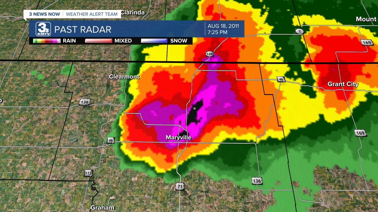
The storm crossed into Missouri, where it took aim at the city of Maryville. Winds over 80 mph, even approaching 100 mph, and large hail battered the city. It was one of the worst storms in the city's history, where damage was extensive across town.
Further east, another storm developed near Denison and dove south-southeast through western Iowa. In Harlan, strong winds damaged several sheds across Shelby County before crossing into Pottawattamie County.

The storm gained strength in Montgomery County, where towns such as Stanton and Villsica were slammed by baseball-size hail and 60 mph winds. However, the greatest damage occurred in Taylor County near Gravity, where winds over 70 mph and baseball-size hail caused significant damage to the town.
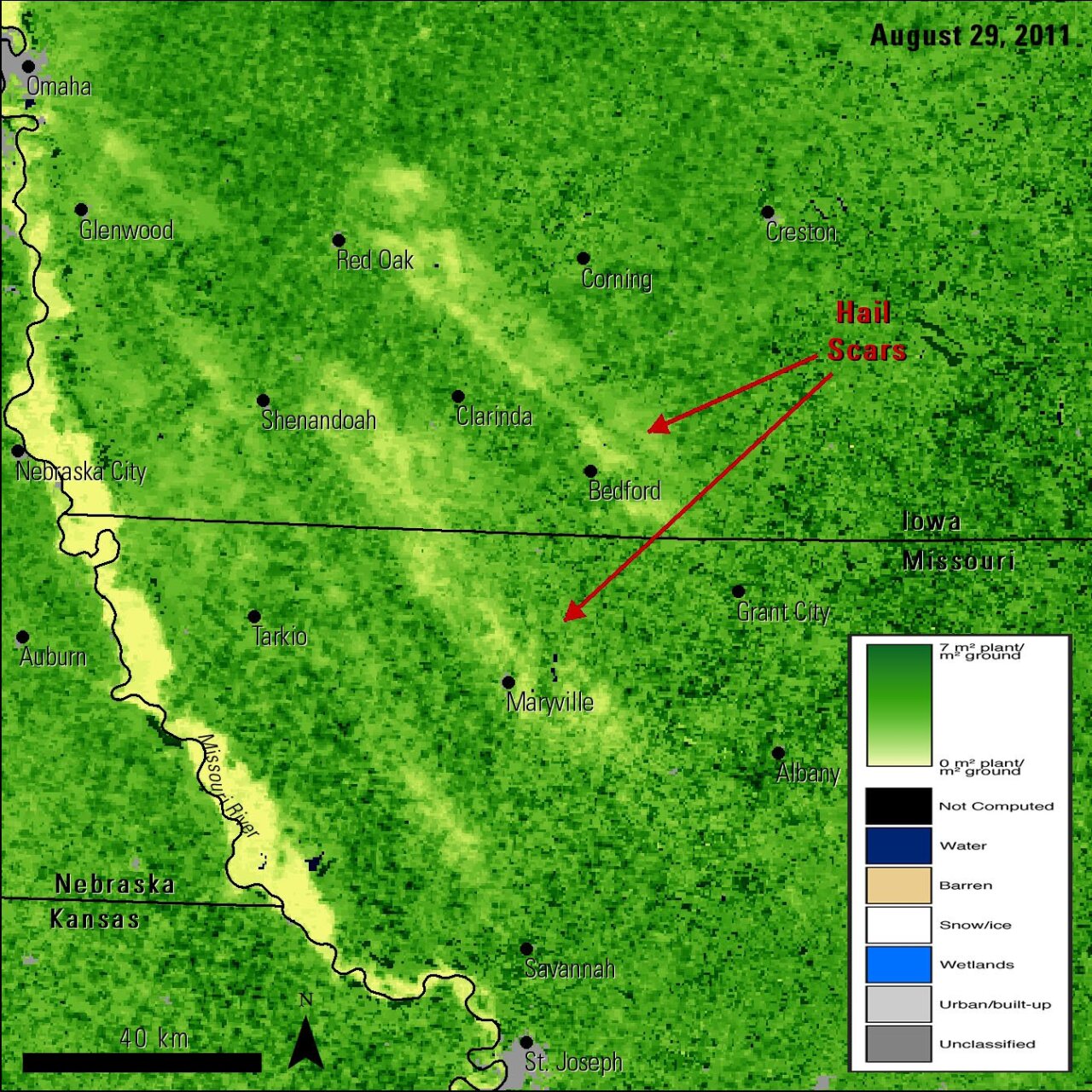
Satellite imagery reveals the extent of the damage across southwest Iowa into northwest Missouri.
As the region recovered somewhat, the same windstorm which brought the 90 mph winds through the Omaha metro barrelled through southwest Iowa into northwest Missouri. Winds up to 70 mph and golf ball size hail caused more damage in Fremont County Iowa to Holt County MO. Further south, damage was done in St. Joseph, Kansas City, and the Missouri State Fairgrounds in Sedalia.
When the event was said and done, the hailstorms on Aug. 18 caused millions of dollars in damage from Omaha to southwest Iowa to northwest Missouri. In northeast Nebraska, a lone supercell produced a tornado near Ewing east of O'Neill and prompted tornado warnings as far south as Columbus and York. It was the final nail in the coffin to an already miserable summer of 2011, as the storms of June 20, and the Missouri River flooding showed.
