When you think of August, images of summer come immediately to mind, August is one of the hottest and most humid months for the Midwest. Tornadoes are often not associated with August in Nebraska and Iowa, but they can happen. One of the strongest tornadoes to occur in August happened in Fremont County, Iowa on August 28, 1979. In this installment of This Week in Weather History, we look at the violent tornado that ravaged Fremont County, Iowa.
THE SET-UP
August tornadoes are rare in Nebraska and Iowa because of the jet stream's position in the far northern US into southern Canada. This keeps the wind energy for tornadoes focused in the Dakotas/Minnesota/Canadian prairie states and away from Nebraska and Iowa. Occasionally, the jet stream does dive south enough to get tornadoes, like what happened in 1928, but this is somewhat rare.

August 28, 1979, was one of those exceptions. There was enough southward dip in the jet stream to bring some wind shear to the region, but not enough for a regional outbreak of tornadoes. A cold front was moving southward through Iowa, running into the warm and moist environment ahead of it. However, tornadoes were not favored in Iowa due to the weaker wind shear. The tornado that hit Fremont County was the strongest tornado of the day, the only other two tornadoes in Iowa were brief and focused in northern Iowa. So, how did Fremont County see a tornado?
The answer likely lies in the smaller-scale mechanics of tornadoes. Thunderstorms can interact with the environment much as the environment acts on a storm. Storms can modulate their area to make somewhat unfavorable conditions for tornadoes, favorable. This can happen by favorable storm interactions, the presence of a boundary, or other microscale features the meteorological mind cannot fully grasp at this time. Because we did not have the radar or satellite access we do today, this mystery will likely remain unsolved for some time in the case of August 28, 1979.

Forecasts that morning called for isolated thunderstorms, but nothing too significant. The meteorologist on duty at the National Weather Service in Omaha, James Zoller, told newspapers later that they did not expect the rapid development of violent storms that evening. "I have never seen explosive development of a storm like this one. At 4:30 and 5 pm, there wasn't much of a cumulus cloud on satellite photos. Nothing. Between 6 and 7, we had thunderstorms, and shortly after 7, we issued a tornado warning." He wrote to the Omaha World-Herald the day following the tornado.
THE TORNADO
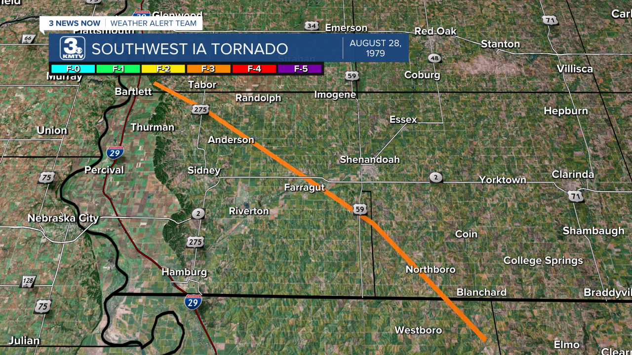
However the tornado came to be, it did, beginning south of Glenwood in Mills County. The tornado was initially brief, lifting as it continued southeast. This spared Tabor, which was right in the path had it still been there. It then began its larger damage track south of Randolph in eastern Fremont County, where one farm home sustained significant damage.

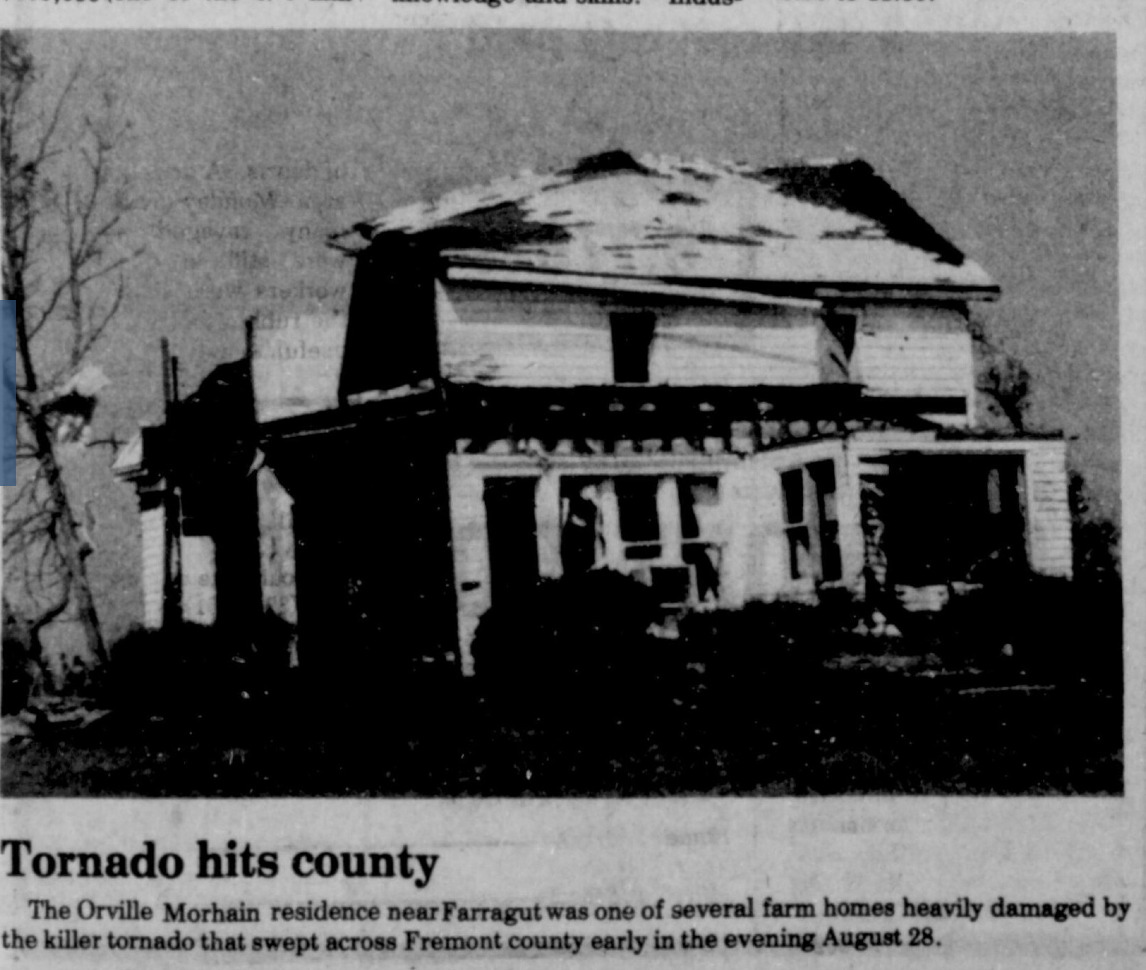
The tornado would track southeast, missing locations such as Anderson, Farragut, and Shenandoah. One farm home was destroyed in the tornado, the family was in Omaha that evening, so they were uninjured. As the tornado tracked southeast, it damaged almost two dozen residences as it passed through. The damage ranged from minor roof damage to complete devastation on a few farms. One farm lost its entire home, with only the front porch steps remaining.

The tornado crossed Highway 2 just east of Farragut, and one home along the road was destroyed. Tragically, the tornado took its first life as it crossed US-59 south of Shenandoah. Jim Penrod was a truck driver from St. Joseph, Missouri, that afternoon, he was driving on US-59 in his truck when the tornado hit him. The trailer was thrown 150 yards from the road, and his body was later found 50 yards from the vehicle. He was 48 years old.

Jim was not the only life taken in the storm. The second life was 67-year-old Meredith Lovitt, who lived in rural Shenandoah. She was home when the tornado hit, burying her inside the home where she died. Her husband, also at home, suffered hand injuries and was treated at a hospital. Besides the two people, over a dozen were injured in the storm.

The tornado continued southeast into Page County, where it headed for Northboro. Thankfully, the tornado lifted before hitting the town. The final report of the tornado came from far northeast Atchison County, Missouri.
The tornado would become one of the strongest August tornadoes in state history. Officially, the tornado was rated an F-3 by the National Weather Service. However, some tornado experts dispute this rating, believing it warrants a higher rating in the F-4 range. If this rating were verified, it would be the only violent tornado (F-4+) in western Iowa in August. For those who lived through the tornado, it created lifelong memories and stories of heroism and tragedy, many of which remain with those impacted today.


