


This is Part 2 of 3 on the hurricanes of Nebraska, Iowa, and Missouri. Part 1 outlines the background information on hurricanes, while Part 2 will outline some of the major hurricanes that have impacted the United States throughout its history. Part 3 will zoom into the Heartland to look at some of the more notable storms to impact the area.
When you think of Nebraska, Iowa, or Missouri weather, you typically do not think of Hurricanes. Hurricanes and other tropical systems are a problem in the Gulf Coast or East Coast of the United States, or very rarely the West Coast. However, tropical systems have had impacts in parts of the Midwest. How? Well although they are no longer hurricanes they still move ashore as remnant tropical systems that can dump heavy rain, bring gusty wind, or even spawn a few tornadoes.
So in this installment of This Week in Weather History, we will look at some of the tropical systems that brought significant impacts to parts of the Midwest.
HURRICANES: FROM EXPLORATION TO REVOLUTION
Almost from the day Europeans began to explore the New World hurricanes became a hazard to fear. In 1502, Christopher Columbus was on his fourth and final voyage to the New World when he ran into a hurricane off the coast of Hispaniola. This was not the last time the Spanish dealt with a hurricane. In 1559, the Spanish attempted to settle a colony near Pensacola, Fla. when a hurricane wrecked the colony, forcing the Spanish to abandon it. In 1565, a hurricane hit the east coast of Florida where competing French and Spanish interests clashed.
The English colonists also dealt with hurricanes. Some historians postulate that a hurricane was the cause of the mysterious disappearance of the Roanoke Colony in the 1580s. Hurricanes also impacted the Jamestown settlement as well as the new British colony of Bermuda. In 1635, a major hurricane struck the new Plymouth Colony in Massachusetts causing significant damage. Virginia was rocked by a hurricane in 1667, and another near Florida in 1715.
During the colonial period, no hurricane season was more destructive than in 1780 in the Caribbean. In 1780, the American Revolutionary War was in full swing, and the Caribbean was filled with British, French, and Spanish fleets all fighting each other. In early October 1780, the first of three great hurricanes known as the "Savannah-la-Mar Hurricane" decimated the British Colony of Jamaica and the Spanish colony of Cuba. It is perhaps best known for the plight of the British warship the Phoenix as it got caught in the storm between Jamaica and Cuba.

Nearly two weeks later, the "Great Hurricane of 1780" hit the Leeward Islands in the eastern Caribbean. The islands of Martinique, St. Lucia, St. Vincent, Barbados, and others were hit the hardest with entire communities flattened. Death toll numbers range in the 20,000 to 30,000 range, which easily places it as the deadliest hurricane in the Atlantic of all time. The trilogy was completed when a third hurricane destroyed a Spanish fleet in the Gulf of Mexico, known as "Solano's Hurricane" after the Spanish commander. The 1780 hurricane season also impacted the Revolutionary War by turning the attention of British and French fleets away from the Caribbean and towards the Atlantic. Some historians believe that the 1780 Hurricane Season was so destructive in the Caribbean that it permanently altered the economic status of the region, ending its colonial boom and fostering independence movements amongst its people.
19TH CENTURY HURRICANES
The young United States continued to deal with hurricanes during its first few decades as a nation. In 1815, the "Great September Gale" swung into the northeast U.S. causing damage in places like New York City and Rhode Island.
The invention of the telegraph has propelled meteorology into a new age, as weather reports could be submitted nearly instantaneously. In 1870, the precursor to the National Weather Service was created under the control of the U.S. Army Signal Corps, whose responsibility it was to begin issuing hurricane warnings for the U.S. beginning in the late 1870s. After scandals plagued the Signal Corps, in 1890 the weather service was transferred to the Department of Agriculture and named the U.S. Weather Bureau.
The Weather Bureau had its hand in hurricane forecasting and warning a few years after its birth as one of the more destructive hurricane seasons hit the U.S. hard, the 1893 hurricane season. The first hurricane was noted by the weather bureau in late August 1893 in the western Atlantic, but it was thought to be offshore. The next day, the hurricane barreled into New York City as a Category 1 hurricane on Aug. 23 which caused major wind and flooding damage in the city.
Two days after the New York City Hurricane, Aug. 25, the Weather Bureau noted another hurricane southeast of Florida and issued hurricane warnings from Florida to New York City. Eventually, the Weather Bureau predicted it would make landfall near Savannah, Ga., but their warnings came too late. On Aug. 27, the hurricane made landfall as a Category 3 near Savannah, catching those on the islands off the Georgia coast completely by surprise. Many of the islands were completely submerged, and most of the fatalities occurred there. General estimates of the "Sea Island Hurricane" runs between 1,500 and 2,500 people, one of the deadliest hurricanes in U.S. history.
After a tame September, October 1893 was another deadly month. The Weather Bureau predicted light showers in Louisiana on Oct. 1, but what actually happened was a Category 4 hurricane coming ashore in Louisiana which was completely undetected. In particular, the island of Cheniere Caminada was destroyed and was where most of the fatalities occurred. The death toll of the "Cheniere Caminada Hurricane" was around 2,000 people, making it one of the deadliest hurricanes in US history and surpassing the "Sea Islands Hurricane" just two months earlier.

1900 GALVESTON HURRICANE
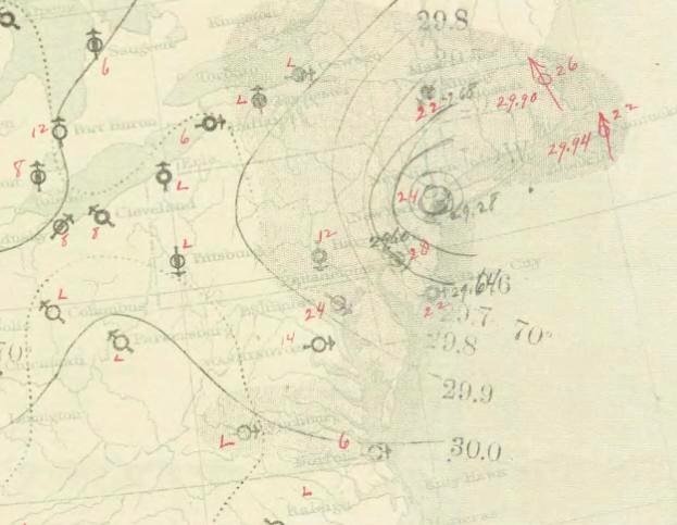
On Aug. 27, 1900, ships sent the Weather Bureau notification of some strong winds. It was the first detection of a tropical system in the Atlantic. Over the next few days, the tropical system became a hurricane as it moved into the Caribbean and hit the west side of Cuba. U.S. Weather Bureau meteorologists thought it would curve into Florida, while Cuban meteorologists thought it would head towards Texas. Weather Bureau suppressed the Cuban predictions, but the Cubans would be right as the hurricane headed right towards Galveston, Texas.
In 1900, Galveston was one of the largest cities in Texas as both a business and leisure hub for Americans. The population of the city was around 40,000 people. The people of Galveston were lulled into a false sense of security that hurricanes would not impact the port city. Their fears were alleviated by Weather Bureau meteorologist Isaac Monroe Cline, who wrote extensively about how Gulf hurricanes miss Texas due to geography and other barriers. In fact, he was so confident in his assumptions that he purchased a home for his family near the coast. Up until the hurricane made landfall Isaac Cline believed his city was safe, even when the Weather Bureau told him to hoist the hurricane warning flags on the evening of Sept. 7.

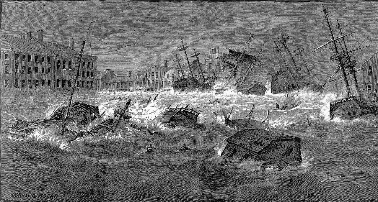
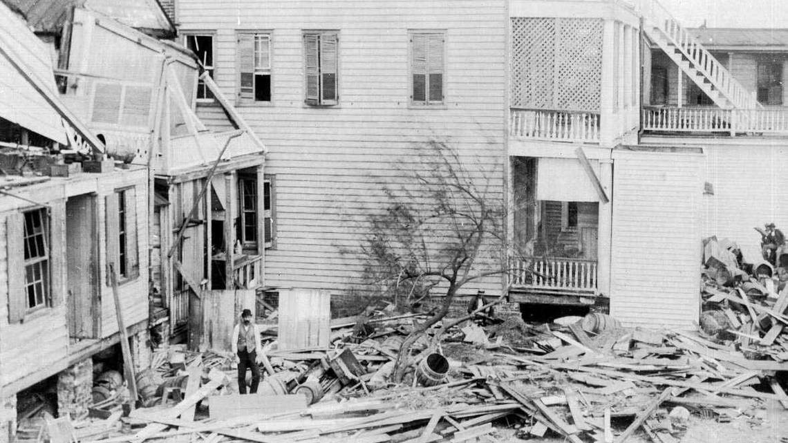
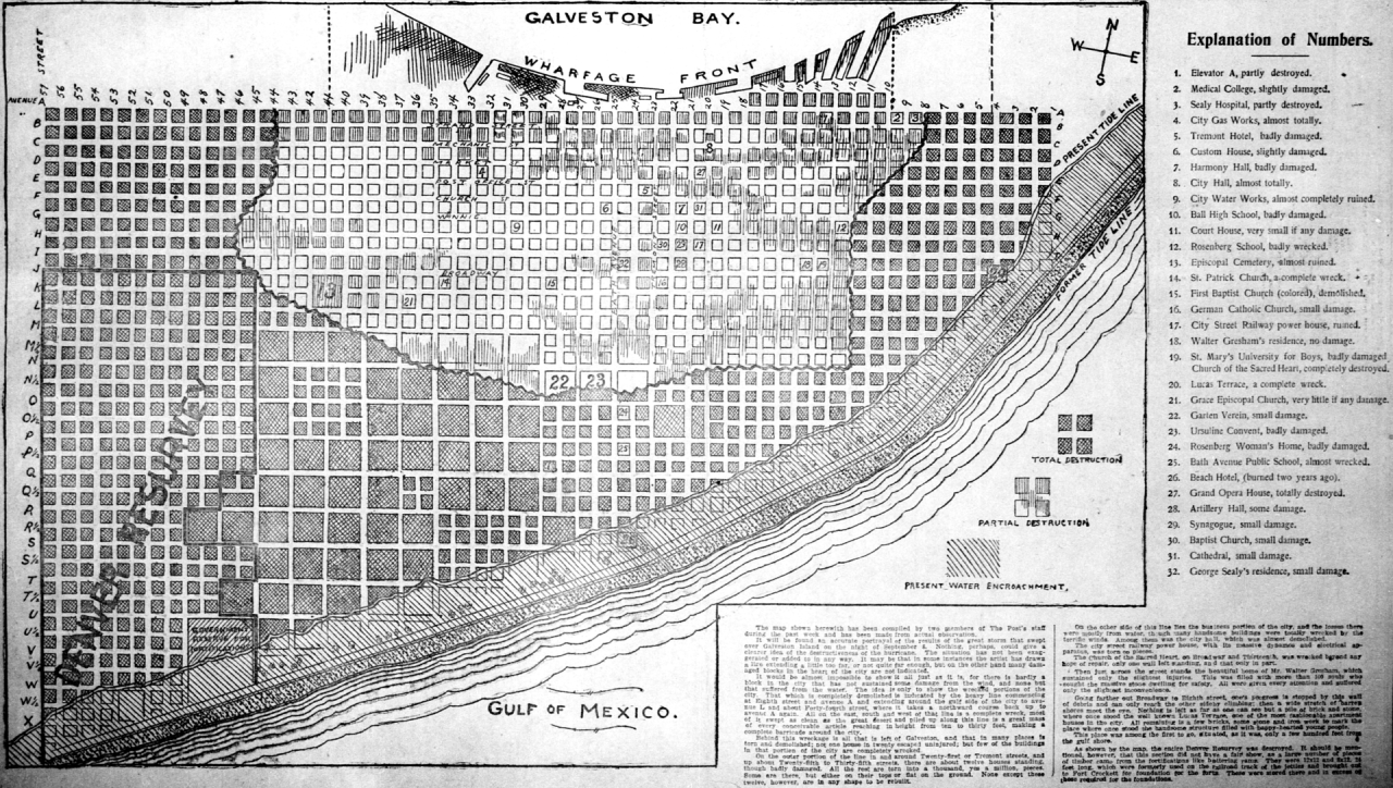
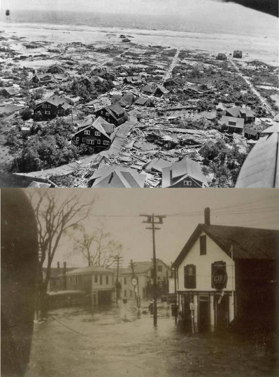
The hurricane smashed into Galveston on the morning of Sept. 8 as a Category 4 storm bringing high winds and a major storm surge. Many of the beachfront homes many blocks in, were demolished by the rising tide. The debris from those homes eventually made a makeshift dam, sparing the downtown part of Galveston from the floodwaters. Stories of tragedy abound from the storm. At an upscale saloon downtown, businessmen were gathered for lunch not letting the storm get in the way. Suddenly, the roof crashed onto the men killing five and injuring the rest. Another scene of tragedy came from St. Mary's Orphanage a few miles from Galveston. The sisters working there tied the children up in bunches with rope and sat in the chapel singing hymns as the water rose higher. They moved to the second floor and waited out the hurricane as the building gave way. The rope tied to the children became a death trap as it dragged them underneath the water, killing nearly everyone at the orphanage except three older boys who were not tied up.
Even Isaac Cline did not escape tragedy, his family was in their home when the hurricane struck, and Isaac alongside his family fought for their lives as the floodwaters rose in the home. Eventually, the home was torn apart and he alongside his three daughters, pregnant wife, and brother were swept into the floodwaters. Isaac, his daughters, and his brother all survived. Tragically, his wife Cora did not make it.
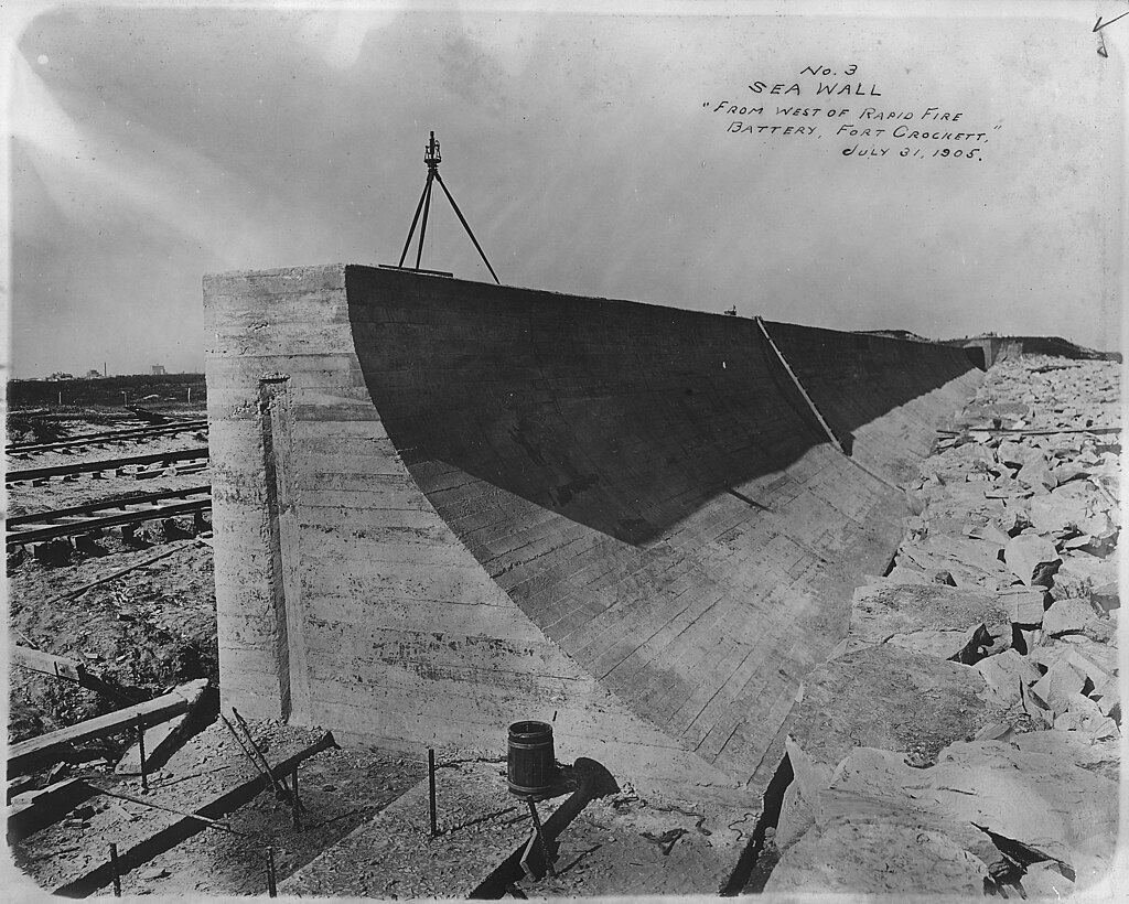
The aftermath of the Galveston Hurricane was grisly. The death toll is placed at around 6,000 on the lower estimate, with reasonable estimates as high as 10,000 or more. It remains the deadliest hurricane in U.S. history and nearly wiped Galveston off the map. Galveston did recover, but it never gained its economic prosperity as before the hurricane, as that economic center moved to nearby Houston. Ten years after the hurricane, a large seawall was constructed to protect the city from the storm surge. Today, Galveston is better protected from hurricanes due to the engineering feat.
FLORIDA'S DECADE OF DESTRUCTION: 1926-1935
In the 1920s, Florida was in the midst of a major land boom. After Henry Morrison Flagler alongside John D. Rockefeller, one of the founders of Standard Oil, saw the potential in the state he had a railroad built along Florida's east coast that would connect Jacksonville with Key West in 1912, Florida exploded. Miami, a city that did not even exist until the 1890s felt it in full force. The 1900 census put its population at 1,681 and by 1910 it was up to 5,471. In 1920, it was close to 30,000 and rising even higher by 1925, when the city's population ballooned to 84,000 residents. Other cities such as Coral Gables, Fort Lauderdale, Jupiter, and Miami Beach also exploded in popularity. Rich citizens flocked to Florida as a real estate boom began, land was being purchased before homes were ever built at astonishingly high prices. Speculation was rampant across Florida, and its growth placed it as one of the fast-growing parts of Roaring 20s America. With every rise comes a fall, and Florida's fall could almost directly be tied to hurricanes. Between 1926 and 1935, the Sunshine State was rocked by three major hurricanes which plunged it from boom to bust. The first hurricane would target the city of Miami itself.
The Weather Bureau first detected the "Great Miami Hurricane" on Sept. 14, 1926, west of the Bahamas. The city of Miami went to sleep thinking a tropical storm was heading for the city overnight on Sept.18. However, no one had predicted that the hurricane would intensify to a Category 4 before making landfall in Miami. The city felt the wind grow in force to over 120 mph, then it became calm, and the eye passed right over the city. Many residents of Miami never experienced a hurricane before and believed the storm was over. Citizens went outside to inspect the damage, caught in the open as the more vicious second half of the storm came ashore.
Around 400 people were killed in the hurricane, around 150 of those in Miami, and the rest across southern Florida. The University of Miami welcomed its first class in the fall of 1926 and named their team the "Hurricanes" after the storm.

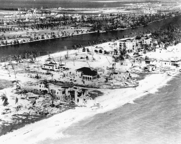
Two years later, Florida would be hit with its second hurricane of the stretch. Forecasters first noted the storm on Sept. 9, 1928, over the open Atlantic. The hurricane strengthened rapidly making landfall in Puerto Rico as a Category 5 storm with winds in excess of 160 mph. On the island, 600 were killed and over half a million were left homeless. Forecasters then predicted the hurricane would curve away from Florida, but as it kept moving northwest towards the state those forecasts shifted to a major hurricane making landfall somewhere in southern Florida. The hurricane made landfall near Palm Beach as a strong Category 4 storm on Sept. 16, causing significant damage along the beachfront of southern Florida.

As it moved inland, the hurricane would spend its fury over the Everglades and Lake Okeechobee inland. An already wet summer had stressed the dike system surrounding the lake, and the hurricane tipped it over the scales. Being buffeted with 120 mph winds, the dike system holding the southern part of the lake back failed, inundating the small villages of southern Florida with a wall of water 20 feet high in some places. The "Lake Okeechobee Hurricane" of 1928 took an estimated 2,500 to 3,000 lives by modern estimates, many of those living in the Everglades.

The combination of these two hurricanes ended the Florida land boom and might have been one of the first precursors to the financial crash of 1929 beginning the Great Depression. The depression stunted Florida's recovery after being battered by hurricanes. However, one government project continued in building a highway connecting Miami with Key West, replacing the old railroad which was becoming rotted. To assist with this construction, many World War I veterans were sent to build the highway, many living in encampments on the shallow Florida Keys.
On Aug. 30, 1935, a disturbance was noted by forecasters near the Turks and Caicos Islands. Moving due west, it was expected to potentially make landfall somewhere in southern Florida to the Florida Keys. Taking advantage of the warm waters, the hurricane intensified to a Category 5 as it passed near the Florida Straits, missing mainland southern Florida. The Weather Bureau believed it would pass between Florida and Cuba into the Gulf of Mexico, but to their surprise, the hurricane took a sharp jog to the right and barreled almost due north right into the Florida Keys.

Realizing their mistake, a relief train was sent immediately from Miami to collect the veterans stuck on the keys. Unfortunately, it was already too late and the train faced further delays. The train made it to the first few camps, but eventually, the strong winds and high surf derailed the train in the keys.
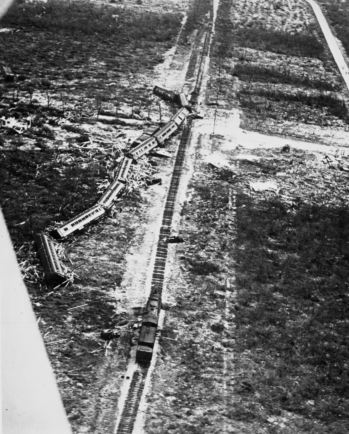
Help was not coming to the other veterans, and they felt the brunt of one of the most powerful hurricanes to make landfall in U.S. history. Known as the "Labor Day Hurricane of 1935", the hurricane is still the lowest pressure observed from a landfalling hurricane in the U.S. Winds were sustained at 185 mph with gusts up to 200 mph. In the aftermath, almost 500 people were killed, with 272 of those deaths being veterans stuck on the keys.

1938 GREAT NEW ENGLAND HURRICANE
Florida was the sight of much of the hurricane action of the 1920s into the early 1930s, but attention would quickly swing to New England when one of the worst hurricanes in its history impacted the region in September 1938.
The hurricane was first spotted on Sept. 16, 1938 west of the Bahamas. Believing Florida would take another hit, Weather Bureau forecasters quickly warned the state of the approaching storm. However, no such storm came to Florida, as the hurricane began to curve to the north. By this point, hurricanes that began their curve towards the north will deflect away from the U.S. as they go around the Bermuda High. However, in 1938 the Bermuda High was much further north than usual, and one forecaster believed it would curve the hurricane due north into New England. The senior meteorologist in charge disagreed and sought to use the word "gale" to warn New England. What actually occurred was a Category 3 hurricane slamming into Long Island and the rest of New England.
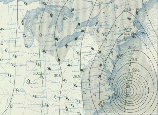
The hurricane, caught in the Gulf Stream, accelerated to over 50 mph as it rammed into Long Island. Waves 30-50 feet high battered the coastline as residents scrambled for shelter. Across Connecticut, winds over 100 mph caused significant damage to many homes and buildings. Rhode Island saw tides higher than the 1815 gale, sending much of the capital of Providence underwater. In total, 680 people were killed in the New England Hurricane, and thousands were injured. At Yale and New Haven Connecticut, nearly half the trees were snapped and stripped of their leaves.
To this day, it is one of the greatest disasters in New England history.
1954 HURRICANE SEASON
Beginning in the 1940s, hurricane forecasting accelerated into the modern era. Airplanes began reconnaissance missions into hurricanes to gather information on their wind speed, direction, and pressure. This evolved into the modern Hurricane Hunters, who fly into tropical systems to report back meteorological data. With the advent of radar, hurricane tracking and movements became more accurate and warnings became better. Satellites proved pivotal to hurricane prediction in the 1950s, and the NHC now uses up-to-the-minute satellite data to track hurricanes. While this story so far has been failures by the Weather Bureau to predict hurricanes, the predictions become a lot more accurate beginning in the 1950s onward.
Some of these strides began in 1954 when several major hurricanes impacted the east coast of the U.S. The first one was Hurricane Carol (the Weather Bureau began naming hurricanes after female names in 1950), first identified in late August 1954, It quickly went up the east coast and made landfall near Long Island. 60 people died and 200 people were injured by Carol.


Not even a month later, Hurricane Edna made similar trajectories toward New England. Edna went further east than Carol, making landfall on the easternmost tip of Cape Cod in Massachusetts. In October, Hurricane Hazel became the finale of the 1954 Atlantic Hurricane Season. It hit Haiti where hundreds were killed in the country before zipping north towards the U.S. Hazel made landfall near the North/South Carolina border and zipped through the eastern U.S. 94 people died in the U.S. and 81 in Canada from wind and flooding.
These three hurricanes, as well as Hurricane Connie in 1955, brought government funding for the National Hurricane Research Project, another important step for the forecasting of hurricanes in the United States.
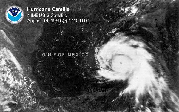
1969: HURRICANE CAMILLE
Before Hurricane Katrina, there was Hurricane Camille. It was spotted by satellite in the Caribbean in early August 1969, moving towards Cuba. After clipping the western tip of Cuba, the storm continued due north despite forecasts believing it might curve east. As it moved north, it took in Gulf of Mexico moisture allowing it to strengthen into a vicious Category 5 hurricane with wind speeds over 190 mph. Camille remains one of the strongest hurricanes in Atlantic history.
It barreled towards the Louisiana and Mississippi coasts, where residents began to board up their homes and shelter. 81,000 of 150,000 people in the evacuation zones left, but there were some who remained behind. Thus, one of the biggest hurricane legends in history developed.
Camille came ashore near Bay St. Louis, Miss. as a Category 5 hurricane on Aug. 17, 1969. The Richelieu Apartments felt it would withstand the hurricane, and many residents did not evacuate. One of those residents was Mary Ann Gerlach, who lived there with her husband. Water came into their apartment, she was sucked out of a window while her husband, who could not swim, drowned.
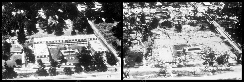
When Mary Ann did interviews afterwards, she claimed that 23 residents were having a hurricane party on the 3rd floor. CBS News Anchor Walter Cronkite reported on the hurricane party, saying, "This is the former site of the Richelieu apartments, where twenty-three people laughed in the face of death, and where twenty-three people died." Despite the legend of the Camille Hurricane Party still present, the story is most likely false. Other survivors, including Ben Duckworth, vigorously denied any such party occurring.
Camille was also one of the first hurricanes that witnessed what today is common in hurricanes, extensive media coverage. With the advent of television, reporters flocked to the Gulf Coast for hurricanes while stations provided round-the-clock coverage. Camille was one of the first major hurricanes to have this kind of coverage, coverage that continues today.
1992: HURRICANE ANDREW
Between Hurricane Camille and Hugo in 1989, there was a relative lack of major hurricane activity to impact the U.S. Hurricane Hugo in 1989 brought significant impacts to South and North Carolina, reminding Americans that hurricanes could still have major impacts.
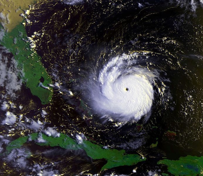
The 1992 Atlantic Hurricane season was very quiet, with no tropical activity from June through mid-August. By mid-August, a weak tropical disturbance was given the name "Andrew". Brian Norcross, former Chief Meteorologist at WTVJ in Miami, was expected to travel to New York City for a new job when Andrew caught his eye. He decided to remain one extra day in Miami to see what Andrew would do. Norcross grew concerned, the expected northwestward deflection typical of hurricanes did not happen. Worse, Andrew was strengthening into a hurricane as it moved towards the Bahamas.
Miami, which had not experienced a hurricane since Hurricane Betsy in 1965, slowly grew more concerned. By the evening of Aug. 23, Andrew was now expected to make landfall as a Category 3 storm in the vicinity of Miami. On the morning of Aug. 24, Andrew was a Category 3 hurricane impacting the Bahamas, and it continued to strengthen. At 11 a.m., it was upgraded to a Category 4 storm. By 5 p.m., it was a Category 5 storm as it made landfall in the Bahamas. It was now only 60 miles east of Miami. Brian Norcross went on the air at 9 a.m. and would not get off until 8 a.m. the next morning. he would ride out the hurricane with the rest of Miami on television.
The National Hurricane Center was not spared from the impacts. The wind gauge measured a staggering 164 mph wind gust before it was knocked out of commission. The radar dome was destroyed, knocking radar service out of commission. The building withstood the 160+ mph winds, but it left significant damage across Miami. Andrew came ashore south of Miami as a Category 5 hurricane. At WTVJ, Norcross was getting concerned for the stability of the station, and he moved the staff into a storage facility nicknamed "the bunker" and rode out the rest of the storm there.

Damage was extensive across the Miami-Dade County area. Homestead, a town south of Miami, was nearly destroyed. 160,000 homes in the metro area were damaged or destroyed. The Miami Airport suffered damage, with over 200 planes tossed around like toys. The Miami Zoo was heavily damaged, and several animals escaped into the wild, including over 300 exotic birds when the Aviary was smashed. Some of these animals lived to breed, introducing lots of invasive species to southern Florida. When compared to other hurricanes, Andrew has a relatively low death toll with 44 deaths in Florida and another six in Louisiana. Many believe this death toll being so low was due to adequate warnings given ahead of the storm.

1992: HURRICANE INIKI
Despite being known as a tropical island, Hurricanes usually don't reach Hawaii that often. Hawaii is a dot in the vast Pacific Ocean, hard to hit. As well, winds are generally unfavorable for hurricanes in Hawaii, and its ocean temperatures are generally too cool for storms. Since 1871 to 1992, only two hurricanes have made direct landfall on the islands. Thus, when Hurricane Iniki made landfall on the islands in September 1992, it hit the region unprepared.

The island of Kauai had some unique guests when the hurricane hit. Steven Spielberg alongside a crew of 130 people were filming "Jurassic Park" on the island when the hurricane hit. The crew took shelter in their apartment as the hurricane hit, with the director calming the younger cast with games as the winds howled outside, tearing up the walls of the hotel ballroom. Some camera crew members ventured out into the storm to get shots of it.. The "Jurassic Park" crew survived Iniki, with many of their sets relatively untouched.

The rest of Kauai did not fare too well, many parts of the island were heavily damaged. 15,000 homes and businesses were damaged or destroyed. Six people were killed. It is the strongest hurricane to make landfall in Hawaii.

2004 HURRICANE SEASON
From the 1990s into the early 2000s, hurricane activity in the U.S. calmed home. In 1998, Hurricane Mitch became the second deadliest Atlantic storm when it made landfall in Honduras killing upwards of 11,000 people.
Hurricanes would rear their ugly head back in the United States during the record-breaking hurricane season of 2004 when four major hurricanes impacted Florida within six weeks of each other.
The first of these was Hurricane Charley, which formed off the African coast on Aug. 4, but did not become a tropical depression until Aug. 9. As it moved into the Caribbean it intensified into a Tropical Storm, then a hurricane as it passed near Jamaica on Aug. 11. On Aug. 13, Charley made landfall in Cuba as a Category 3 storm, the eye passing just a few miles west of Havana. Emerging into the Gulf of Mexico, Charley further intensified to a powerful Category 4 storm as it moved towards Florida's southwest coast. Making landfall near Punta Gorda on Aug. 14. The hurricane was small, which mitigated more widespread damage. However, where Charley did impact the damage was extensive in Punta Gorda and nearby Port Charlotte. Ten people died in the U.S., four in Cuba, and one in Jamaica.


Ten days after Charley, the NHC began watching another tropical disturbance near Africa, becoming a tropical depression on Aug. 25. The following day, the tropical system became Hurricane Frances. It intensified into a Category 4 hurricane near the Turks and Caicos, but weakened as it approached the Bahamas and Florida. Frances made landfall as a Category 2 storm on the east coast of Florida on Sept. 5. Flooding rainfall was the main hazard with Frances as it slowly crossed Florida. Moving over the eastern U.S., Hurricane Frances dropped over 100 tornadoes from Florida to New York.

As Hurricane Francis approached Florida, another tropical system moved off the west coast of Africa on Aug. 31. This tropical system, named Ivan, intensified rapidly and became one of the southernmost major hurricanes on record. It continued to intensify over the Caribbean, becoming a monster Category 5 hurricane as it passed near Jamaica and the extreme western tip of Cuba. It continued into the Gulf of Mexico, slowly weakening to a Category 3 when it made landfall near Gulf Shores, Alabama on Sept. 16. Major damage occurred in Alabama and the Florida Panhandle, being one of the worst storms to impact Pensacola. Interestingly enough, Ivan moved inland producing over 100 tornadoes, then emerged in the Atlantic, moved southward towards Florida again as a weak low, crossed Florida back into the Gulf, restrengthened into a tropical storm, and made landfall in Louisiana on Sept. 24. In the United States, 25 people were killed, while 92 were killed in the entire storm.

As Ivan was barreling towards the U.S. on Sept. 13, a tropical wave became a tropical storm near the Leeward Islands, becoming Tropical Storm Jeanne. Jeanne made landfall in Puerto Rico as a Tropical Storm, and the Dominican Republic as a Category 1 hurricane. North of the country, Jeanne meandered around the Atlantic for several days before moving westward towards the Florida coast. On Sept. 26, Category 3 Hurricane Jeanne made landfall near Stuart, Fla., nearly the exact same spot Hurricane Frances made landfall three weeks prior. Jeanne was deadly in Haiti, where 3,000 people were killed due to the heavy rains, making it one of the deadliest hurricanes in recent history.

2005 HURRICANE SEASON
If the 2004 hurricane season was incredibly active for the United States, the 2005 hurricane season dwarfed it in terms of numbers and intensity of tornadoes.
The first major hurricane to impact the U.S. in 2005 was Hurricane Dennis. It formed off the west coast of Africa on June 29, and developed into a hurricane shortly thereafter. The hurricane intensified into a Category 4 storm south of Cuba, making landfall shortly after on July 8. As it crossed into the Gulf of Mexico, it weakened to a Category 1 before rapidly strengthening into a Category 4 storm as it approached the Florida Panhandle. The region was hit by Ivan the year prior, and Dennis would impact the same area when it made landfall near Navarre Beach, Fla. as a Category 3 on July 10. Three people died in the United States, 22 in Haiti, 16 in Cuba, and one in Jamaica.
The next major hurricane to impact the United States during the 2005 hurricane season is perhaps the most infamous hurricane of all time, Hurricane Katrina. Hurricane Katrina remains one of the deadliest hurricanes in modern U.S. history, the costliest in U.S. history, and the most controversial. It would take an entire article of this length to discuss every aspect of Katrina as many factors conspired to create the disaster of truly historic proportions. Thus, a brief overview will have to do.
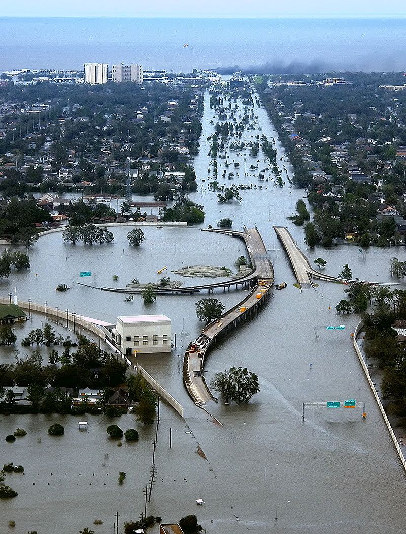
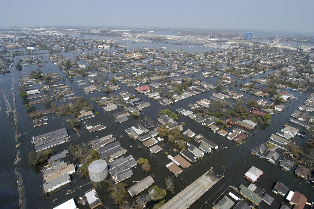
Katrina developed as a tropical wave on Aug. 24, becoming a Category 1 hurricane on the 25th. It made landfall in southeast Florida shortly thereafter, causing moderate impacts in southern Florida. Crossing into the Gulf of Mexico, it intensified into a Category 3 hurricane as it moved right towards New Orleans. New Orleans sits below sea level, protected by the levee system which was built several decades before. However, due to a variety of factors such as lack of funding, the levee system had critical issues that were not addressed, making New Orleans a sitting duck as Katrina continued to gather strength.
On Aug. 28, Katrina continued to intensify, reaching Category 5 intensity as it continued to move towards New Orleans. Local, state, and federal authorities began declaring states of emergency and urging evacuations. Early in the morning on Aug. 28, the mayor of New Orleans ordered a mandatory evacuation of the city, with critics claiming it was done too late. Still, 80% of the city's population evacuated in the day before the storm. Those that did not, predominantly lower-income people, did not have the means or the capability to evacuate. Buses meant to evacuate residents sat empty as there were no bus drivers, as the mandatory evacuation order did not allow for that, it was a state decision. Many went to the Superdome to shelter from the hurricane and brace for impact as Katrina spent its fury. It made landfall in eastern Louisiana as a Category 3, east of New Orleans, then made landfall in Mississippi later on Aug. 29. It was devastating for Mississippi, 239 people were killed and many communities in Mississippi suffered extensive damage.
It was New Orleans where disaster hit in full force. Heavy rainfall and storm surges stressed the levee system to its limit, and in the coming days after Katrina, it broke. Levee after levee failed from Monday, Aug. 29 into Wednesday, Aug. 31, submerging 80% of New Orleans with many inches to feet of water. For days, those who were unable to leave their homes were forced into attics or roofs to suffer in the extreme heat with little food or water. The Superdome became a horrific place of thousands of people eating limited food, power was out as was water, meaning no one could use the restroom. For days, it was a true humanitarian crisis in New Orleans.
Help was slow to arrive on all levels, trickling in during the days after Katrina. It took a week before most residents were safely transported to other locations. President George W. Bush did not arrive until Friday, Sept. 2. Most of the blame has been laid at the feet of FEMA, who failed to react decisively in the days following the hurricane due to a variety of reasons. Even when they arrived, they failed to act, leaving many residents of New Orleans to feel abandoned by the government. The director of FEMA resigned on Sept. 12, and the fallout from Katrina affected the popularity of the Bush presidency to this day. Even still, the response to Katrina is seen as one of the worst governmental failures in history.
In all, Katrina killed an estimated 1,200 people. Damage was estimated at $193 billion dollars as of 2023 money, making it the costliest hurricane in U.S. history. It has become the most infamous hurricane in U.S. history from the strength to the response.
As the U.S. dealt with the aftermath of Katrina, on Sept. 16 another tropical system developed near the Turks and Caicos. It gained the name Rita and quickly intensified from a Category 2 to a Category 5 hurricane within 24 hours on Sept. 21. The hurricane was moving towards Texas and southwest Louisiana. The expectation of another major hurricane in the immediate wake of Katrina's disaster sent panic through Texas and Louisiana. An estimated 2.5-3.5 million people evacuated in the days leading up to Rita, the largest evacuation in U.S. history. What was a three hour drive from Houston to Dallas became 24-36 hours as highways across Texas fell into gridlock during a heat wave. People running out of gas on the interstate left them stranded in their cars during the heat, leading to several heat-related deaths. At least 60 people died during the evacuations, with some estimates over 100. In actuality, Rita made landfall in southwest Louisiana as a Category 3, with impacts not as severe as expected in Houston. Three people died directly to the hurricanes, with the rest of the deaths as a result of the botched evacuations.

The final devastating hurricane in 2005 was Hurricane Wilma, which developed over the Caribbean in mid-October. It strengthened quickly to a Category 5 hurricane as it neared the Yucatan Peninsula, dropping to the lowest pressure any Atlantic hurricane has. It slowed as it made landfall near Cozumel, causing catastrophic damage. It then quickly accelerated towards Florida, making landfall as a Category 2 hurricane as it rapidly crossed the peninsula in five hours. 22 people were killed due to Wilma, Five from the United States.

2012: SUPERSTORM SANDY
The 2012 hurricane season had been relatively benign for the United States. So when a tropical system developed in the central Caribbean heading north, there was not much chatter about Sandy. Most computer models had Sandy heading over Jamaica and Cuba, then heading into the open Atlantic with no threat to the U.S. However, some computer models, namely the European models, had Sandy doing something quite unusual. Instead of heading out to sea like 99% of hurricanes do, it had it make a sharp curve to the left into New Jersey. Only one or two other hurricanes had done this in history, but could it be true?

By Oct. 25, that scenario became the likely outcome as it impacted Jamaica and Cuba, causing millions of dollars in damage and killing 12. In Haiti, still recovering from the earthquake of 2010, 24 people were killed in flooding rainfall. As Sandy clipped the Bahamas, one other person was killed. Preparations for Hurricane Sandy ramped up across the eastern seaboard as it crossed into some interesting meteorology where it would combine with a low-pressure system becoming extratropical. Thus, the "hurricane" became the "superstorm" which spanned much of the eastern U.S. The largest Atlantic hurricane since at least 1988. It would arrive in the northeast around Halloween, this coincidence caused the media to dub it the "frankenstorm" as it moved towards New Jersey.

The governors of New York (Andrew Cuomo) and New Jersey (Chris Christie) declared states of emergency and issued evacuation orders. There was some hesitance in issuing larger preparations due to the nature of the storm, since it was not a "hurricane" impacts were perceived as lesser than if it were a hurricane. Plus, a year earlier in 2011 Hurricane Irene was expected to be severe in the same areas, but was perceived as not having significant impacts. As the storm approached, the messaging from forecasters got more significant and finally pressed local authorities to issue preparations in advance of Sandy.

Sandy started making impacts on Oct. 29 when strong winds and storm surge buffeted a wide swath from North Carolina to Massachusetts but made its worst impacts on New Jersey and New York. Winds over 60 mph knocked a crane down in New York City, but the worst came overnight. New York City was in the worst spot, the waters of the Atlantic were channeled into the city, and the superstorm struck at high tide during a full moon. Subway systems were submerged, and Manhatten was inundated with 4-9 feet of storm surge, flooding out many basement apartments.

In New Jersey, significant damage was done by Sandy. In a rare move for a tropical system, snow fell in parts of the Appalachian Mountains, some spots as high as three feet. When the damage was done, 72 direct deaths and 87 indirect deaths were caused by the superstorm.

THE HURRICANES OF RECENT HISTORY
Recently, 2017 has been the hurricane season which rivals the hurricane seasons of 2004 and 2005 in terms of intensity and impact. 2017 saw three hurricanes make landfall in the U.S. at Category 4 intensity, something that has never happened before in U.S. history.


2018 brought more significant impacts by hurricanes.


The 2020 Hurricane Season has been the most active season on record in terms of named systems. Once the alphabet is used, names are transferred to the Greek alphabet, which was scrapped after the 2020 season.


If you managed to get to this point, thank you for reading all of that. In part 3, we look at the specific storms to impact Nebraska, Iowa, and Missouri. Do not worry, it will not be as long as this post was.
