


This is Part 3 of 3 on the Hurricanes of the Heartland. Part 1 outlines the background information on hurricanes, while Part 2 looks at the Hurricane Hall of Fame. Part 3 will be the final one, looking at the notable storms that have impacted Nebraska, Iowa, and Missouri.
When you think of Nebraska, Iowa, or Missouri weather, you typically do not think of Hurricanes. Hurricanes and other tropical systems are a problem in the Gulf Coast or East Coast of the United States, or very rarely the West Coast. However, tropical systems have had impacts in parts of the Midwest. How? Well although they are no longer hurricanes they still move ashore as remnant tropical systems which can dump heavy rain, bring gusty wind, or even spawn a few tornadoes.
So in this installment of This Week in Weather History, we will look at some of the tropical systems that brought significant impacts to parts of the Midwest.
Let's address the elephant in the room, hurricanes do not impact the Midwest. While yes, Category 5 hurricanes do not raze cities in the Midwest, remnant tropical systems can often bring impacts to the region. The two primary hazards is flooding rainfall and gusty winds, and that is what these following tropical systems brought.
1900 GALVESTON HURRICANE
Much of the details on one of the most destructive hurricanes in U.S. history is in part 2, but this part specifically focuses on its impacts in the Midwest.
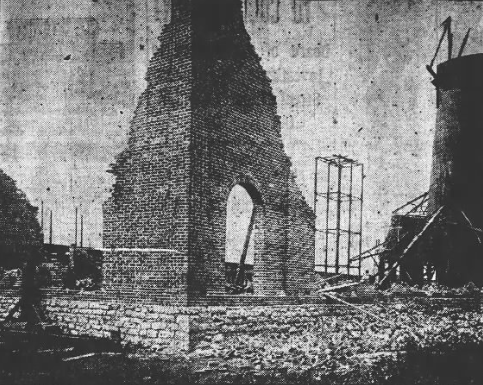
After devastating Galveston, the hurricane began its northward jog into the southern U.S. As it continued inland, a curious phenomenon ensued where the storm actually intensified somewhat on land. This was probably due to its interaction with a cold front or other low-pressure system. This meant that as the hurricane passed into the Midwest on the morning of Sept. 11, 1900, impacts were significant.

In Omaha, wind gusts reportedly hit 58 mph at their peak, but spent much of the night gusting over 40 mph. The city's electrical grid, not that old, was plunged into darkness in several spots of town. In Dundee, the winds snapped trees and broke windows, as did a window near 24th and Lake Streets. Rainfall exceeded three inches in the city. Further south, an unofficial estimate of six inches fell near Falls City, which is perhaps the rainiest tropical system in Nebraska state history. Since this is pre-1950, that record is not official.

The impacts were felt further east through the Midwest. In St. Joseph, Mo., one person was killed by a falling chimney and another suffered serious injuries. In Chicago, winds were measured at 84 mph, the equivalent of a Category 1 hurricane, causing damage throughout the city. Two people were killed in the city, and several others were injured. Rough seas in the Great Lakes led to many maritime issues, and there was even some storm surge in Michigan and Ohio. Across New York and New England, winds of 50-70 mph caused sporadic damage across the area. The hurricane dissipated as it crossed back into the Atlantic.
1961: HURRICANE CARLA
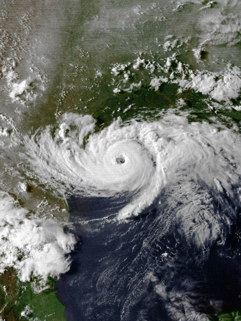
Hurricane Carla formed in early September 1961 in the southwest Caribbean. Within a few days on Sept. 5, it became Tropical Storm Carla as it moved northwest. The next day as it approached the Yucatan Peninsula, it became a Category 1 hurricane. Crossing near Cancun, Carla continued to strengthen as it moved into the Gulf of Mexico. As it approached Texas, Carla became a powerful Category 4 hurricane with winds upwards of 145 mph. At the time, it was believed that Carla reached Category 5 intensity. However, in 2018 a reanalysis study determined that Carla only achieved Category 4 intensity.

Carla made landfall in Texas on Sept. 11, 1961, as a powerful Category 4 storm. Damage was significant along the Texas coast, with many beachfront communities hit hard by the winds and storm surge flooding. One unique aspect of Carla was its localized tornado outbreak along the Texas coast, including an F-4 tornado near Galveston, one of only two F-4 tornadoes ever spawned by a hurricane.

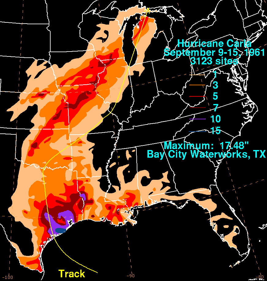
Carla began lifting north and ran into a cold front diving southward from the Midwest. The combination of Carla's tropical moisture and the cold frontal moisture brought widespread heavy rainfall across the Midwest. A corridor of heavy rain fell from Kansas through Nebraska, Iowa, and Wisconsin. Nebraska, Iowa, and Wisconsin, it is officially the highest tropical-related rain in their histories. At Hubrell in Thayer County (southeast of Hastings), 5.68" of rain is the state's highest rainfall. In Iowa, 9.03" of rain fell in Chariton. In Missouri, 9.35" fell in Concordia.

The worst of the storm's impacts were in Kansas, where rainfall 4-7" flooded our many roadways. Five people drowned in Kansas from floodwaters. On top of that, winds of 40-60 mph across the Midwest brought crop damage to areas too. In terms of rainfall, Carla was one of the most impactful tropical systems in the United States.
1983: HURRICANE ALICIA
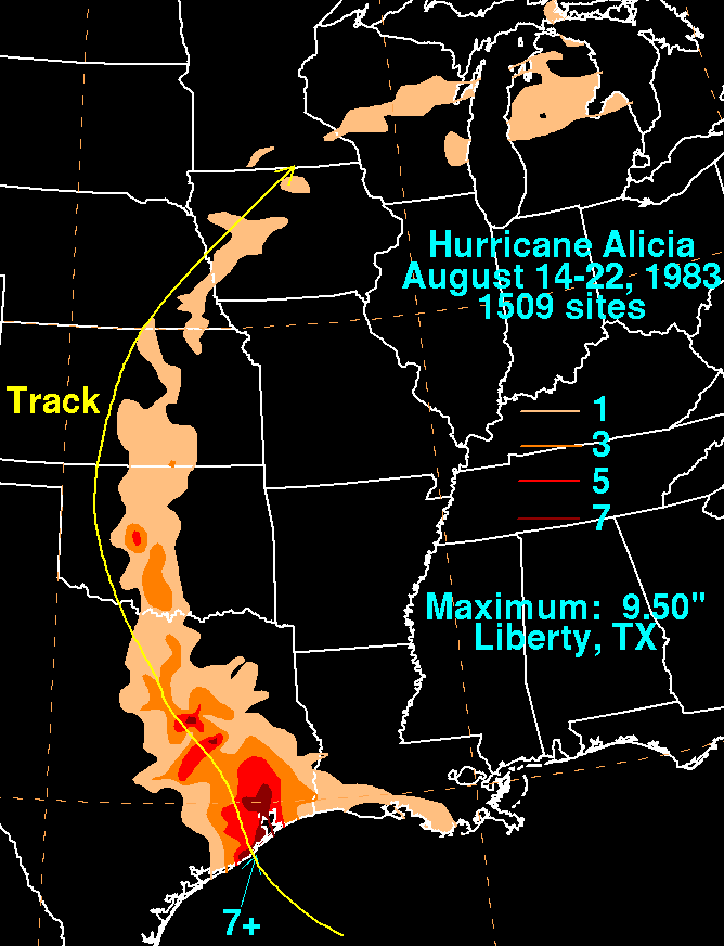
A less impactful tropical system brought rainfall to southeast Nebraska in late August 1983 when the remnants of Hurricane Alicia moved through Nebraska. Alicia is the only time that a tropical storm still had a defined center over southern Nebraska, but it lost its steam. 1-2" of rain fell across southeast Nebraska to Omaha, helping put a dent in a very dry summer so far.
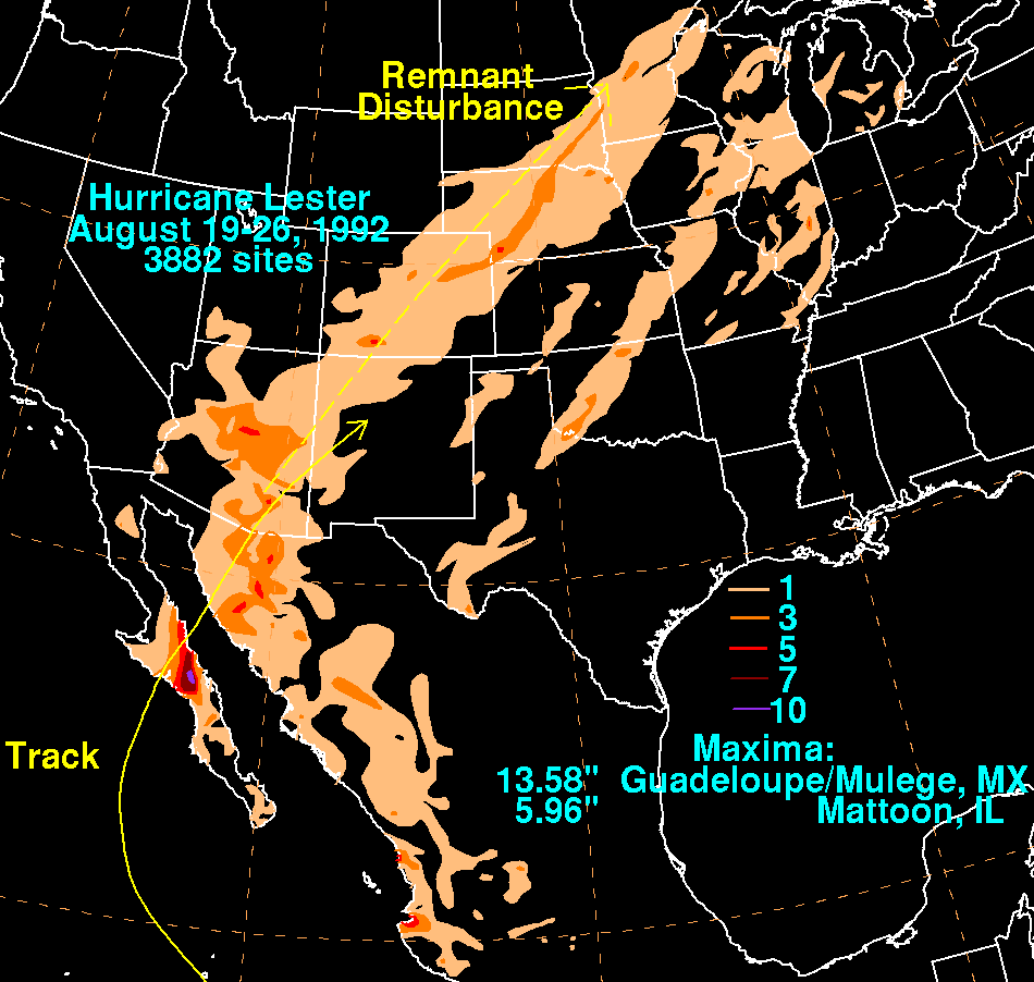
1992: HURRICANE LESTER
The origins of Hurricane Lester were from the west coast of Africa and drifted across the Atlantic and Caribbean with little notice from forecasters. By mid-August, the wave passed over Mexico and emerged over the eastern Pacific, where it became Tropical Storm Lester. As Hurricane Andrew was heading towards southern Florida, Lester became a Category 1 hurricane as it made landfall near Baja California, where moderate impacts were had.
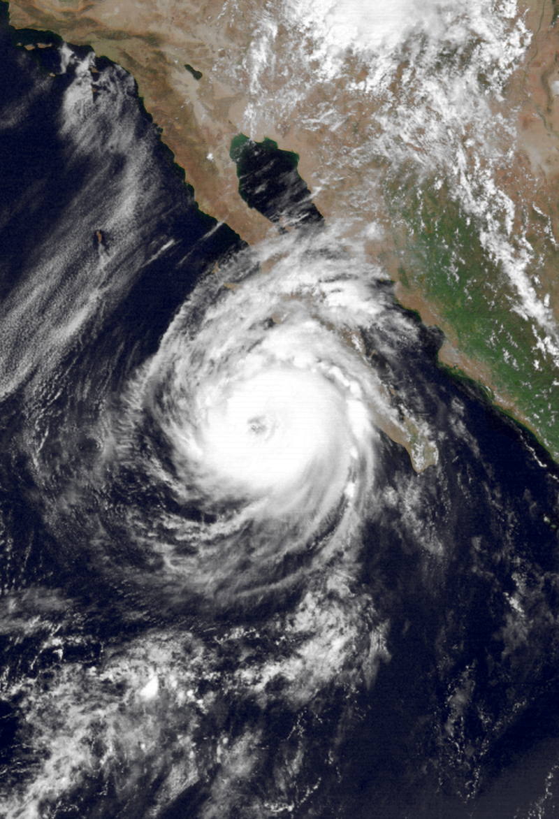

The moisture associated with Lester was pumped into the southwest, causing heavy rain from Arizona to Colorado, and finally into Nebraska. Rainfall amounted from 1-3" in most of northern Nebraska, while most of the rain missed Omaha.
2008: GUSTAV AND IKE
While tropical systems are rarer in Nebraska and Iowa, they are more common in Missouri where its closer proximity to the Gulf frequently sees remnants move in. However, none had more impact on the state than September 2008, when two major hurricanes brought widespread flooding to the state.
The first of these was Hurricane Gustav, which began as a tropical wave off the coast of Africa before moving into the Caribbean. On Aug. 26, it became a Category 1 Hurricane Gustav as it made landfall in Haiti. After hitting Haiti, it made landfall in Jamaica as a tropical storm. After leaving Jamaica it began to rapidly strengthen into a 155 mph Category 4 before making landfall in Cuba, where it made major impacts. It weakened as it moved over the Gulf of Mexico due to unfavorable winds, making landfall in Louisiana as a Category 2 hurricane on Sept. 1.
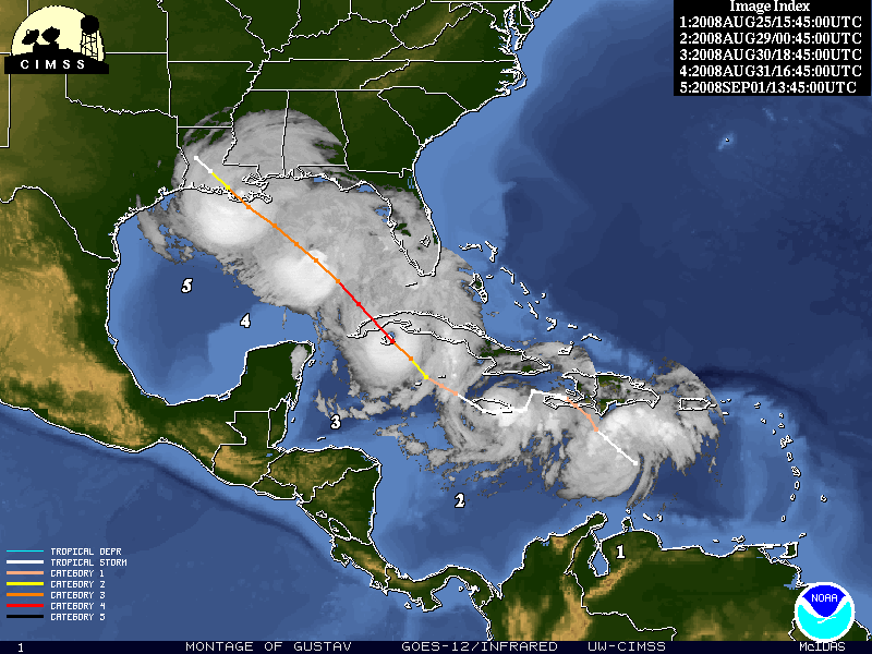
As it moved inland, it slowed down over Texas into Arkansas, rainfall was heavy producing double-digit rainfall across Arkansas. In Missouri, a widespread 3-5" with isolated amounts of 7-10" was spread throughout much of the state.

The day Gustav made landfall, Sept. 1, the NHC named a Tropical Depression which was later to become Hurricane Ike. After struggling at first, within 24 hours Ike exploded from a tropical storm to a Category 4 hurricane. It made landfall as a Category 4 hurricane in Cuba, the second one to do so in two weeks. Ike encountered the same unfavorable winds when it made landfall in Galveston, Texas as a Category 2 storm. As Ike moved inland, heavy rainfall fell from Texas to the Great Lakes, but the worst impact of Ike was in Missouri where the recent heavy rainfall from Gustav created flooding.
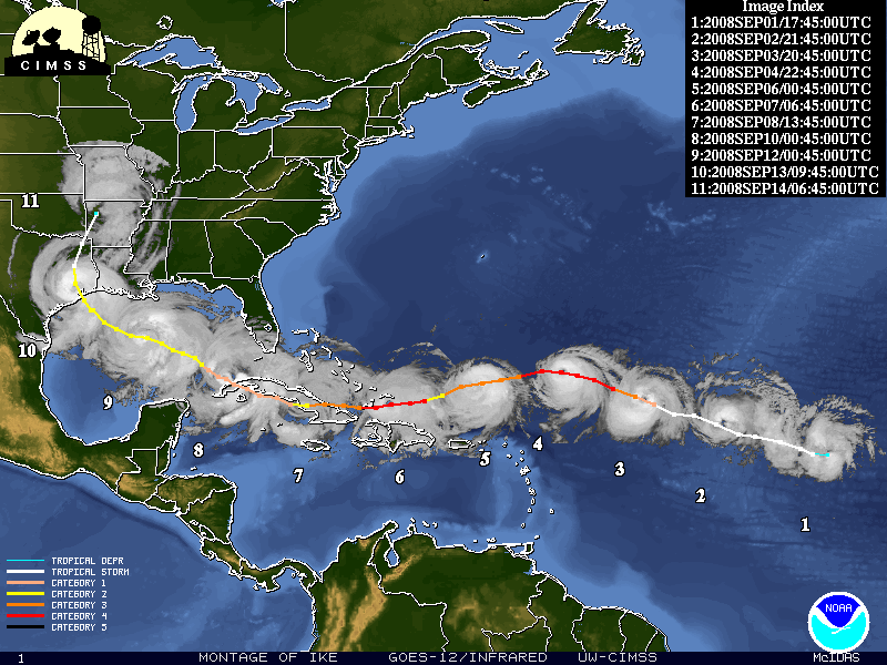
Across the St. Louis metro, rivers swelled over top roadways and buildings, causing some historic flooding in the city. Northern Missouri was also the site of significant flooding as another 5-10" fell on top of the last 5-10" of rain from Gustav.
2012: HURRICANE ISAAC
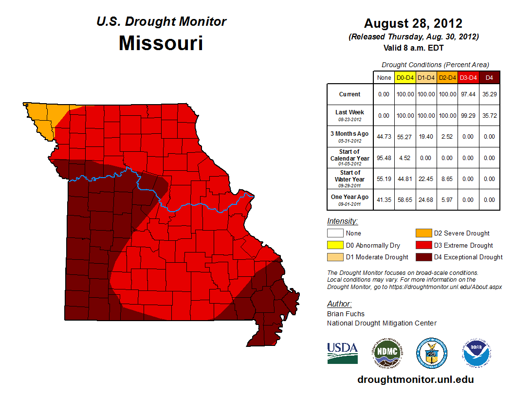
Besides Hurricane Sandy, the 2012 hurricane season was relatively tame for the United States, with the other major storm of note being Hurricane Isaac. Hurricane Isaac managed to nearly end the drought in Missouri, as well as bring a new hazard not seen in the Midwest from tropical systems.
Isaac became a tropical depression on Aug. 21 as it approached the Leeward Islands. It struggled with generally unfavorable winds and rapid movement, never strengthening above a Category 1 hurricane as it made landfall in Louisiana on Aug. 29. It moved through Arkansas into Missouri on Aug. 30 into Aug. 31, where it produced rainfall across much of the state.

Rainfall ran from 2-6" generally, a welcome sight for the drought-stricken Missouri. Areas that were in the exceptional (5/5) drought on Aug. 28 were knocked down to the severe (3/5) category all thanks to Isaac.
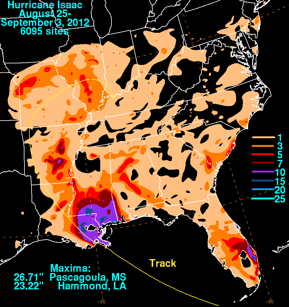

Another hazard Isaac brought was tornadoes, a threat not commonly seen from tropical systems in the Midwest. Two tornadoes occurred in the St. Louis metro area, including one which hit a school in O'Fallon northwest of St. Louis. This is the only occurrence of a tropical-related tornado in the state of Missouri.
Those are just a few of the tropical systems to impact the Midwest, there are others and there will be others. It's just an example that the Midwest can truly experience almost every type of weather.
