
When thinking of severe weather, our minds often go to tornadoes, the most devastating kind of severe weather. However, thunderstorms that contain high winds can also do an equal amount of damage over a wider swath. Omaha gets its fair share of these squall lines which bring down trees and lead to power outages.
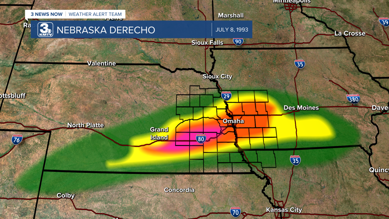
The most dangerous of these windstorms are known as derechos, a term you may or may not have heard before. Recently, a derecho blasted through northeast Nebraska into Iowa on August 10, 2020. That derecho was the costliest thunderstorm in US history, but other derechos also are destructive. One of the costliest non-tornadic storms in Nebraska history was a derecho. During the evening of July 8, 1993, a line of storms went from North Platte to Des Moines, causing significant damage over a wide swatch of southern and eastern Nebraska. In this installment of This Week in Weather History, let's talk about the costliest thunderstorm in Nebraska history.
WHAT IS A DERECHO?
A derecho (pronounced durr-ray-show), a Spanish word meaning "straight ahead", is the meteorological term to mean a long-lived widespread windstorm. A derecho has specific requirements, like a blizzard, to be classified as one. The qualifications are:
-The continuous swath of wind damage at least 400 miles long, or roughly the length of Nebraska
-At least 60 miles from end to end
-Wind gusts over 58mph across most of its length, with occasional wind gusts over 75mph at various spots along its length
Historically, derechos are more common over Iowa and the rest of the corn belt, although Nebraska occasionally sees a derecho. According to the map, Omaha sees a derecho around once every 2 years.
THE 1993 DERECHO
The hot weather on July 8 sparked off thunderstorms over northeastern Colorado. These storms gained in intensity as they continued into southwestern Nebraska. At first, these storms were isolated and produced large hail and even a brief tornado southwest of North Platte. It was as these storms approached Kearney that they formed into a line, and between Kearney and Des Moines, the damage was extensive.
Kearney and Minden were the first communities to be hit by winds over 80mph. In Kearney, winds estimated at 90mph ripped through a mobile home park. Of the over 100 trailers, 68 were destroyed, and 23 people were injured. Luckily, no one was killed in the storm. The rest of Kearney suffered extensive damage, estimated at around 10 million dollars.
Just south of Kearney is Minden, where winds over 80mph ripped up a hanger at the airport and threw planes onto the runway. West of Minden, a brief tornado touched down near Axtell.
In Kenesaw, 20 miles west of Hastings, winds estimated at around 100mph isolated the town from the rest of the county as the damage was too extensive to reach them. The sewer system was damaged, along with numerous trees and home damage. Damage was done in Hastings and Grand Island. Huge transmission lines connecting Grand Island to the south of Lincoln were nearly all toppled by the huge winds.
As the storms left the tri-cities, it picked up in intensity doing its greatest damage in York, Polk, Seward, Butler, Lancaster, and Saunders Counties. The damage is outlined one by one.
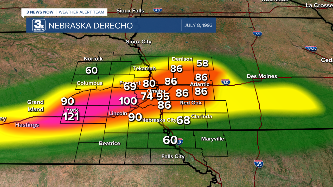
Polk County - Most of the damage, estimated by winds between 90-100mph, was done in the southwest part of the county. Near Polk, half the town was knocked out of power with extensive tree damage. Near Stromsburg, a 100-year-old barn was picked up and thrown into the nearby farm home. The force of the barn shattered the windows, spraying the occupant with broken glass.
York County - This is where the highest wind speeds were measured, at around 125mph. Damage across the county looked like a tornado tore through. Billboards were snapped, hundreds of trees uprooted, and buildings lost roofs. On I-80, a tractor-trailer was blown into the ditch.
Butler County - Nearly every home in the county had some sort of tree damage. Winds were estimated at over 90mph in the county, knocking out power to David City and other communities.
Saunders County - Winds upwards of 100 mph ripped apart a shed and snapped trees east of Wahoo. Major damage also occurred in Ceresco and Ashland, mostly to trees and power lines.
Lancaster County - Outside of Lincoln, the damage was extensive over the northern side of Lancaster County. An F-1 tornado packing winds of 100 mph began south of Malcolm and struck a school near Raymond before continuing near Davey, lifting east of US-77. Elsewhere, major damage was done to trees and power lines.
Lincoln - The storm hit Lincoln the hardest, with some areas reduced to "looking like a warzone" as one eyewitness claimed. Thousands of trees were downed across town, some landing on cars or homes. Two F-1 tornadoes also struck town. One of them began over the Lincoln Airport and moved into a mobile home park on the north side of town, where several mobile homes were flipped or damaged, with one injury. The second tornado began near Conestoga Lake and hit Pioneers Park, where a performance of "The Music Man" was ongoing. When it hit, 650 attendees fled for shelter as the tornado ripped up the stage, no one was injured. This tornado continued into the city where damage was done before lifting near 68th and O streets. Some residents were without power for up to a week, and it took many months to replant all the trees the city lost.

The derecho continued east into the Omaha metro. A wind gust of 72 mph was recorded at the National Weather Service office at the North Omaha Airport (72nd and McKinley Streets). Across the Omaha metro, extensive damage was done to trees, particularly in the western part of Douglas County. One home near Waterloo had its roof torn off, and a gas station lost its canopy near 42nd Street and Ames. The canopy landed on several parked cars, one of them with children inside, but they were reduced with no injuries. In Douglas County, over 200 homes were damaged, 32 of those with major damage. In Bellevue, several mobile homes were overturned by the 70 mph winds near Offutt AFB. The damage in the Omaha metro alone exceeded 10 million dollars.

South of the metro, the storms ripped into Cass and Otoe Counties. Buildings were damaged in Palmyra and Unadilla, and campers were overturned at the Louisville State Recreation Area. Trees were snapped in Mahoney State Park, Weeping Water, and Union. Up in Blair, north of the metro, 80 mph winds ripped into several barns on the north side of town and destroyed them.
The storms continued into western Iowa, where they lost none of their punch. 80-90 mph winds snapped 13 metal power poles on the east side of Council Bluffs. A church was blown off its foundation in Bartlett (Fremont County). In Glenwood, a woman was injured by flying glass when the windows shattered in her home. Red Oak had significant tree damage and one shed was destroyed. The storms finally began to lose their steam as they moved into central Iowa, where 70 mph winds continued south of Des Moines.
The July 8, 1993, derecho left extensive damage in its wake. Thousands of trees snapped, hundreds of power poles were down, dozens of homes were destroyed, 30 people were injured (most of them in Kearney), and no fatalities. The damage was totaled up to be in the hundreds of millions of dollars, which makes it the costliest thunderstorm in Nebraska history.
Clean-up took weeks as the state also dealt with significant flooding in the floods of 1993. Although no physical evidence of the derecho remains, it left vivid memories of those who lived through it as one of the most powerful storms in their lifetimes, before or since.
