


In the Midwest, we often pride ourselves on how quickly the weather can change on a dime. One day its sunny and 70, the next its stormy, then it snows, all in one week. Perhaps this notion of rapidly changing weather was no more apparent than in November 2005, where within the span of a month the Midwest dealt with tornadoes and blizzards, often just days apart.
In this installment of This Week in Weather History, we look at November 2005 where Iowa saw a tornado outbreak while two weeks later Nebraska experienced one of its worst blizzards on record.
PRELUDE: NOVEMBER 6
It wasn't just Nebraska or Iowa that experienced wild weather, for November 2005 was one of the most active tornado months for the month in history. The first significant bout of tornadic activity occurred during the early morning hours of November 6. Around 2am, a significant F-3 tornado moved through the far south side of Evansville, Indiana. The tornado took direct aim at a mobile home park on the southeast side of town, catching many residents unaware. Tragically, 25 people lost their lives in the Evansville tornado, most of those occurring at the mobile home park.
The tornado continued into the nearby town of Newburgh before lifting. (Video of the local news coverage of this tornado can be found here)
NOVEMBER 12: THE WEATHER SET-UP
Nearly a week after the Evansville tornado occurred, a new area of severe weather was expected, this time further northwest over Iowa. A powerful low-pressure system was moving over northern Nebraska into southeast South Dakota. Ahead of it, unusually warm and humid air made it as far north as Minnesota.

Much of the day was dry thanks to the cap, a layer of warm/dry air that acts as a lid to suppress thunderstorm development. By mid-afternoon, storms began to fire along the Nebraska/Iowa line and quickly became severe. These storms dropped several tornadoes north of Des Moines.
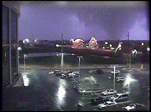
THE TORNADOES OF NOVEMBER 12
The total tornado count for November 12 was 14 tornadoes, 12 of which touched down in Iowa. There were three of particular note due to their intensity.
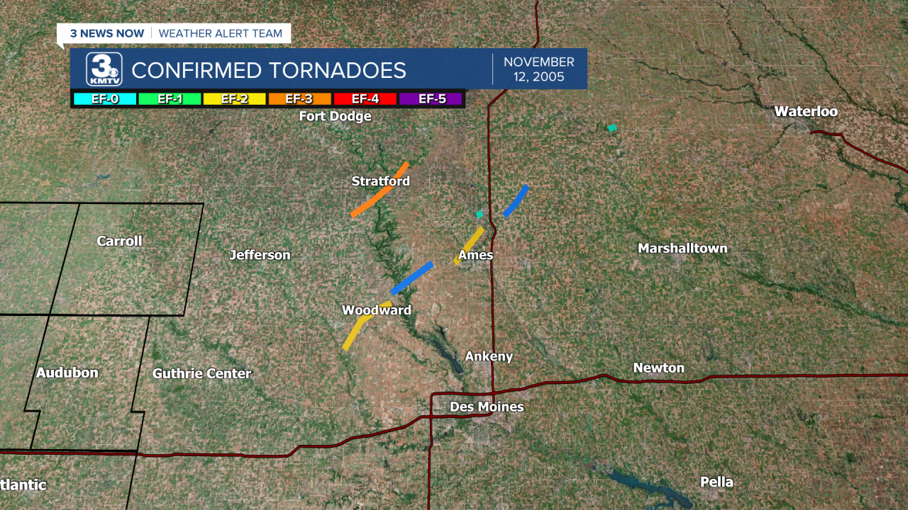
The strongest tornado of the event hit the town of Stratford, the tornado was rated an F-3 as it moved over the northwest side of town. Homes were destroyed, the city park suffered damage, and cars were flipped. One woman was killed in her home. The tornado lifted shortly after striking the town.
Another tornado, rated F-2, touched down in open farmland southwest of the town of Woodward. The tornado moved through the southern and eastern sides of town, damaging many homes and sheds. One home was flipped upside down and tossed into the street, the occupant was injured but survived. Woodward is most famous for a video filmed as the tornado narrowly missed the videographer's home, tearing into the neighborhood. The video has been featured on many documentaries and can be viewed here.

Other tornadoes that day barely missed the town of Ames, home of Iowa State University. The storms weakened and died out shortly after producing the tornadoes as the sun began to set.
November 12, 2005, remains one of the strongest Iowa November tornado outbreaks, although in raw numbers it was beaten out by the November 11, 2015, southern Iowa tornado outbreak.
INTERLUDE: NOVEMBER 15
Just three days after the Iowa tornadoes on November 12, tornadoes once again struck the Ohio River Valley. 49 tornadoes touched down across Missouri, Arkansas, Illinois, Kentucky, Tennessee, and Indiana. The worst of the outbreak was felt in Kentucky, Tennessee, and Indiana.
The outbreak is most famous for an F-4 tornado which moved over the southeast side of Madisonville, Kentucky. Damage to homes and other businesses was severe, with a few homes wiped off their foundations. It would be the strongest tornado of the year 2005.

Some of these areas hit by the F-4 in November 2005 were also affected by another EF-4 which hit on December 10, 2021.
NOVEMBER 27-28: THE SET-UP
November had one more powerful weather system up its sleeve by the end of November. A very powerful low-pressure system developed off the Rocky Mountains of Colorado and moved into the central Plains. It strengthened quickly as it lifted into eastern Nebraska.

The storm system was so powerful in the warm sector that a major tornado outbreak occurred as far north as eastern Kansas, but it spent its fury over northern Arkansas and southern Missouri. Some of these tornadoes were quite strong, up to F-2 and F-3 strength tornadoes were clustered over north-central Arkansas.

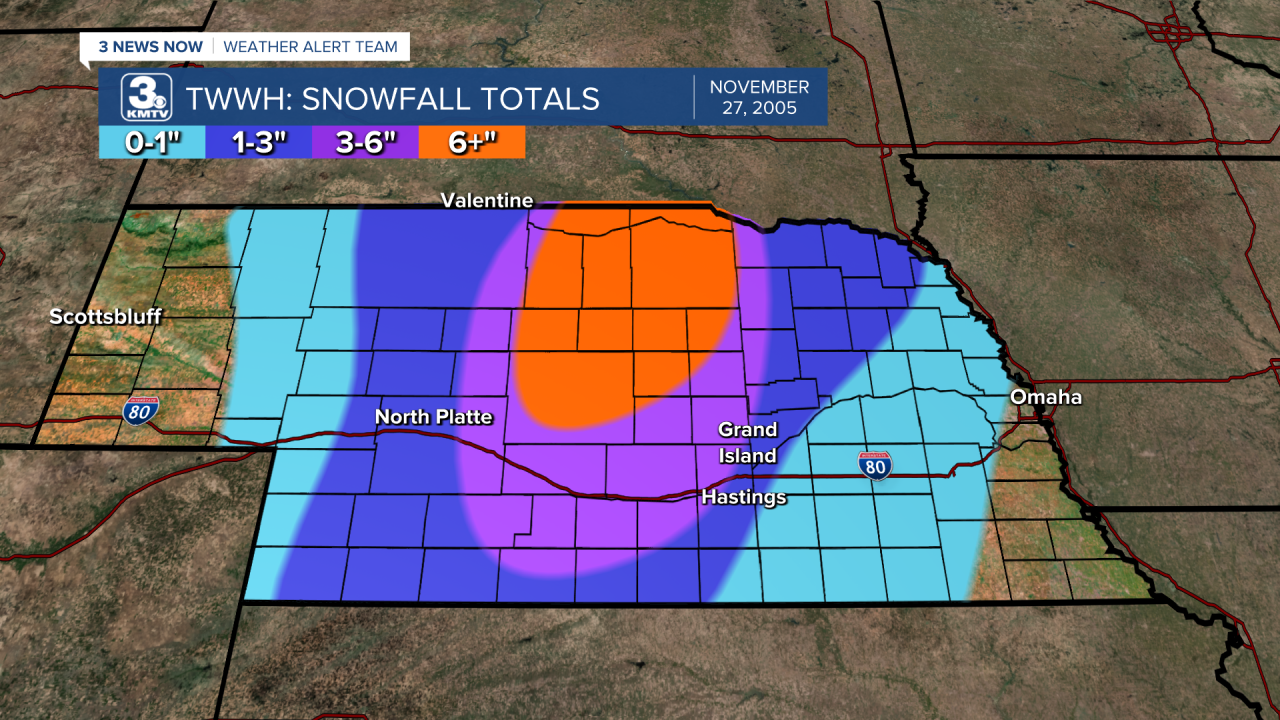
On the backside of the low-pressure system, a powerful blizzard developed over central Nebraska into eastern South Dakota. Due to the extreme wind fields of the storm, the snow was accompanied by wind gusts over 70 mph in spots.
THE BLIZZARD IN NEBRASKA
For a snowstorm to be classified as a blizzard, there needs to be sustained winds over 35mph for at least 3 hours or more. It's about the wind, not the snow. Even if a foot of snow falls, without wind, it does not classify as a blizzard.
However, the blizzard that raged over Nebraska in the final week of November 2005 was a true blizzard. In terms of snowfall, some spots in north-central Nebraska picked up over 1' of snow, but generally 6-12" fell in the blizzard areas.
The worst was the wind, winds were sustained as over 40-50mph for over 12 hours, with some winds upwards of 75mph recorded. One anemometer which was elevated near Ainsworth recorded a 114 mph wind gust, although this did not happen at the ground. The wind, but not the snow, reached Omaha. Omaha recorded winds upwards of 30-40mph, but only around 1/2" fell. The blizzard missed parts of the metro, but northeast Nebraska picked up over 1" with 50mph winds.
The blizzard became a nightmare for travelers post-Thanksgiving, as I-80 was closed over much of Nebraska for 30 to 38 hours. Wind damage was widespread across northern Nebraska. 200-300 center irrigation pivots were overturned, and many hotel signs were broken. One gas station lost its canopy, while tree damage in the Niobrara River valley was extensive. The blizzard remains one of the biggest to strike Nebraska in the 21st century.
