


Thanksgiving week is known as the busiest travel week of the year, beating out Christmas and all other holidays. On average, roughly 50 million Americans drive or fly each year around Thanksgiving. In 2023, early estimates predict over 55 million Americans will be venturing out. Sometimes, Mother Nature cooperates and gives us a quiet week, but other years the worst Mother Nature has to offer is thrown our way during the week.
Mother nature tested the limits of travel during Thanksgiving in 1983, when two back-to-back major snowstorms slammed the United States bringing lots of snow, ice-covered roads, breath-taking wind, and brutal cold all the while Americans were stuck in airports or hotel rooms. These storm systems did not spare Nebraska or Iowa, as both states felt the brunt of these powerful systems. In this installment of This Week in Weather History, we look at the nightmare week of Thanksgiving 1983 to look at the two storm systems that brought the country almost to a standstill.
THE WINTERS OF 1982-83 & 1983-84
For any winter lovers in Omaha, 1982-1984 would've been a dream. From October 1982 to May 1984, 106.8" of snow fell in Omaha over two winters. In 1983 alone, 74.2" fell over the year. This makes 1983 the snowiest year in Omaha history, second place is not even close with 64.5" in 1948. The winter of 1982-1983 saw 51" of snow, while the 1983-1984 winter season saw 55.8" of snow. An average winter in 1983 would've been 31" (in 2023, the number has fallen to 27"), so both seasons saw well above-average snowfalls.
NOVEMBER 1983: THE WEATHER SET-UP
The weather pattern for November was very active, with several large storm systems sweeping across the country. Each one became more powerful than the one before it, with the finale coming Thanksgiving weekend of Nov. 26-27. On Thanksgiving week, three storm systems crossed the country.
The first one brought mainly scattered rain showers to Omaha on Nov. 19, quickly moving away. However, this first cold front brought down some cold air from Canada, which the second storm system would tap into by Nov. 21.
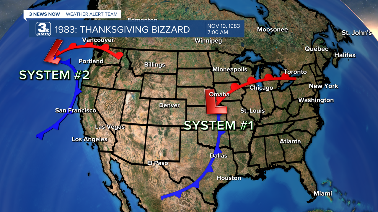
Between Nov. 21-23, the second storm system moved across Nebraska and Iowa dropping light to moderate snowfall amounts. It kept the cold air in place just in time for system 3, the Thanksgiving Weekend Blizzard, to begin its trek across the country.


System 3 crossed the Rockies on Nov. 25 and emerged into the Great Plains on Nov. 26. This low-pressure system was by far the strongest and caused the most widespread impacts to the area.


THE PRELUDE: NOVEMBER 21-23
System 2 which brought snow and ice to Nebraska and Iowa caused headaches in Omaha and around. Officially, Omaha picked up 1.4" of snow, not overly impressive for major snow events. It was the sleet and ice that caused problems, and numerous accidents were reported across the metro. The most significant of these was a 19-car pile-up near 90th and Fort Streets. No one was killed in that accident, although a few were injured. Other minor accidents occurred across the metro.
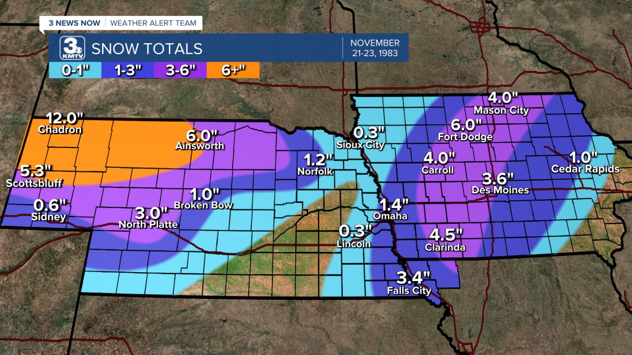
In the rest of Nebraska, snow up to 14" blanketed parts of the panhandle, halting traffic for days in the area. I-80 was closed from Ogallala to the Wyoming border for a time, again stranding many motorists.

In Iowa, one woman was killed on I-35 when her car slid off the road. In Greene County, east of Carroll, two more people died when icy roads led to a head-on collision. A secondary band of snow dropped 3-6" from Clarinda to Mason City, covering the ice and causing more accidents. Hundreds of travelers were stranded for several hours in Iowa as the snow and ice fell.
THE MAIN EVENT: NOV 26-27
Beginning on the heels of the earlier snowstorm, forecasters were eyeing the next storm coming off the west coast of the U.S. "It looks like it's going to be the same sort of thing [referring to the previous snowstorm], another major winter storm" forecaster Bill Hirt told the Omaha World-Herald on Nov. 24. Snow warnings were posted across Nebraska, and Omaha was expected to only receive 1-3" of snow with a glaze of ice before it. No one expected what was about to happen.

It began Saturday afternoon as freezing rain in eastern Nebraska and western Iowa, a glaze of ice soon caused travel headaches as dozens of cars slid into ditches. Fortunately, no major accidents occurred during the freezing rain portion of the storm.

Then the snow fell, and after quickly surpassing the 3" mark in Omaha many knew it was about to be a big storm. When it was all said and done, 10" had fallen in Omaha, with higher totals north and west. From David City to Norfolk, snowfall totals of 18" were commonplace, placing this as November's largest snowstorm for the area. A wide swath of 1-2" of snow fell from Denver to Duluth, stranding thousands of travelers in airports and highways, some seeking shelter in nearby hotels.
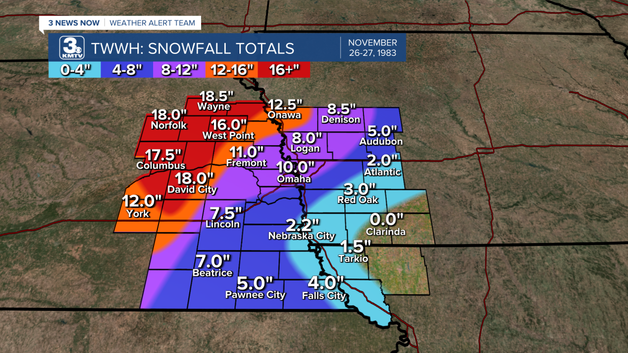
Schools and businesses were closed Monday and Tuesday, extending many Thanksgiving weekends. Children built snowmen and went sledding, one popular spot being a huge snow hill near 50th and Center. Emergency crews worked day and night to clear the snow. Thankfully, the winds were relatively calm in Omaha, meaning power outages remained sparse. By midweek, Omaha got back to normal after the snow began melting some.

In western Nebraska, the National Guard had to be called in to rescue motorists along I-80 who got caught in over 20" of snow that fell. One family near Valentine slid off the road and had to spend the night inside their car before rescue came the next morning. Others sought refuge in hotels, businesses, and homes. Tragically, a few motorists died of carbon monoxide exposure when snow blocked the exhaust pipes of cars. Two people near Ainsworth also succumbed to carbon monoxide poisoning when snow blocked their furnace vent. Outside of Oshkosh in the panhandle, one man was rounding up his cattle when he fell from his tractor, unable to get up, he died of exposure. Overall, at least five deaths are directly attributed to the blizzard, not counting deaths due to heart attacks from shoveling snow.

Iowa was hard hit in the northwest corner, where over 12" of snow fell. In Sioux City, a foot of snow combined with 50 mph winds brought the city to a standstill for several hours. I-29 was closed for a time in Iowa as well. Further south and east snow totals decreased, with southeast Iowa picking up almost no snow.
Overall, the Thanksgiving Weekend Blizzard of 1983 remains one of the biggest snowstorms around the holiday. Impacts were felt from California to Maine, with the hardest hit states being Colorado, Nebraska, South Dakota, Iowa, Minnesota, and Wisconsin. The snowstorm in Denver stopped the city in its tracks for days, and at a point, Denver airport closed completely. During the entire week of Thanksgiving 1983, over 60 people were killed from the blizzard over the weekend and the one earlier in the week.

CODA: DECEMBER 1983
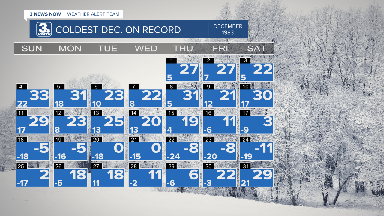
If anyone was sick of winter already after Thanksgiving week, it was about to get a whole lot worse as December 1983 turned bitterly cold across the entire country. The week before Christmas was brutal, with Omaha not seeing any temperature above 0 between the morning of Dec. 18 and the morning of Christmas. The highest temperature during the whole month was 33, meaning there was only one afternoon above freezing in Omaha. The average temperature for December 1983 was 7.8°, by far the coldest December on record in history for Omaha and it is not even close. Since temperatures never rose above freezing, the snow that fell on Thanksgiving did not melt all the way, with 5" of snow depth recorded on Dec. 1. After some more snow events, there was 13" of snow on the ground by Christmas.
Things were not better across the nation, December 1983 was wickedly cold for much of the country. On Dec. 15, cities like Dallas woke up to almost 6" of snow on the ground from a winter storm.
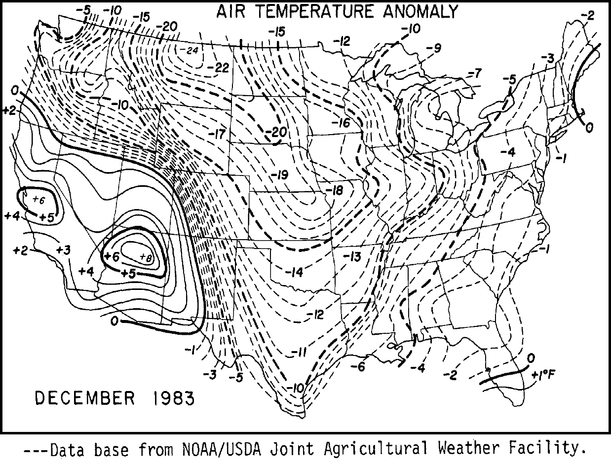
Tragically, the cold snap of December 1983 led to many deaths across the nation, most of them being in southern states where they were unaccustomed to the cold.

After things thawed some in January, the snow continued in Omaha, and the winter of 1983-1984 would become one of the snowiest winters in Omaha's history. Much of this snow came during the Thanksgiving Weekend Blizzard of 1983.
