


In the Midwest, we experience a large amount of weather across all four seasons. Blizzards, tornadoes, extreme heat, arctic cold, floods, wildfires, dust storms, and more. However, hurricanes are one type of weather that the Midwest (thankfully) does not experience. This is obvious why, we aren't on the coast. Despite this, tropical weather can and does impact the Midwest. Once hurricanes come ashore, they can move inland as a remnant system into the Midwest. Although the ferocity of hurricanes is tempered, they can still bring heavy rainfall and flooding, some winds, and even tornadoes.
Only one tropical system has passed over Nebraska, Hurricane Alicia in 1983. Two tropical systems have directly passed over Iowa, the Galveston Hurricane of 1900, and Tropical Storm Cristobal in 2020. Other tropical systems have impacted the two states such as Hurricane Carla in 1961. For more details on these tropical systems, you can read about them in part 3 of the Hurricanes of the Heartland series written last year. Part 1 looks over the science and FAQ about hurricanes. Part 2 is the hurricane fall of fame with the biggest hurricanes to impact the United States.
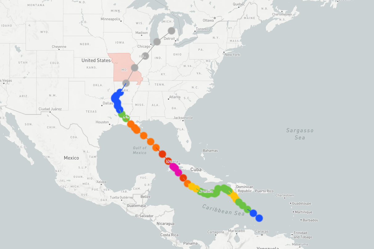
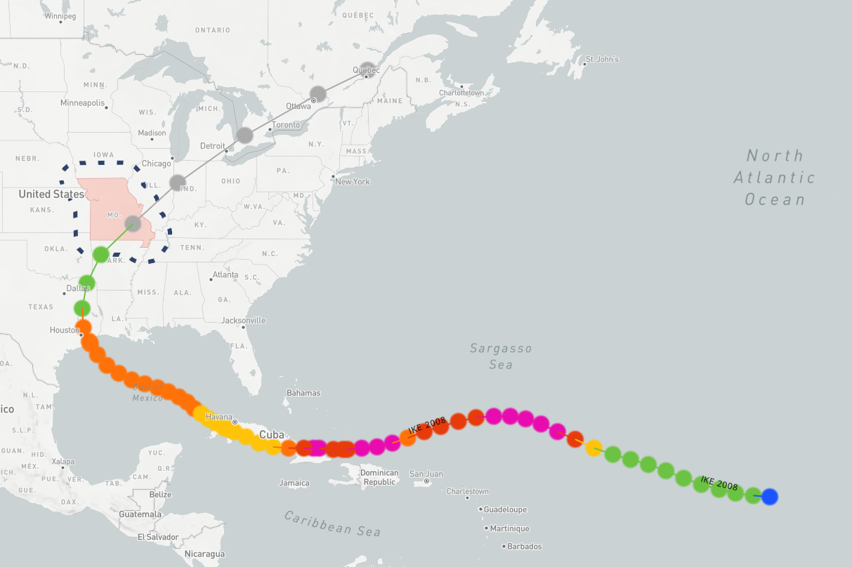
If Nebraska and Iowa hardly experience direct impacts from tropical systems, Missouri has a much more storied history of them. Since hurricane records were kept, 37 tropical systems have passed directly over Missouri. To show the impacts these tropical systems can have, one might not need to look much farther then the dual hurricanes of Gustav and Ike impacted Missouri within two weeks of each other in September 2008. In this installment of This Week in Weather History, we head to the Show-Me State to experience the major impacts brought by two hurricanes within 14 days of each other.
HURRICANE GUSTAV
August 25, 2008, national media attention was focused on the Democratic National Convention in Denver, Colorado. While this was going on, meteorologists focused their attention on a developing tropical system in the central Caribbean Sea. That morning, forecasters at the National Hurricane Center classified the storm as a Tropical Storm, earning the name Gustav. By the next day, Gustav had strengthened into a category 1 hurricane before making landfall in Haiti by midday on August 26. In Haiti, 77 people were killed in the second hurricane to impact the country that year (Hurricane Fay hit a week prior).
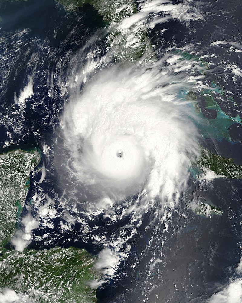
Gustav weakened to a tropical storm before jogging southwestward to impact Jamaica, where 15 people died as a result of the storm. By August 29, Gustav began to intensify between Jamaica and Cuba rapidly. At 1 pm on the 29th, Gustav became a category 1 hurricane. By 7 am on the 30th, it was a category 3 hurricane. Gustav peaked as a dangerous category 4 hurricane as it plowed into western Cuba on the afternoon of August 30th. It was the worst hurricane to hit Cuba in roughly 50 years, it cost an estimated 2.1 billion dollars in the country.
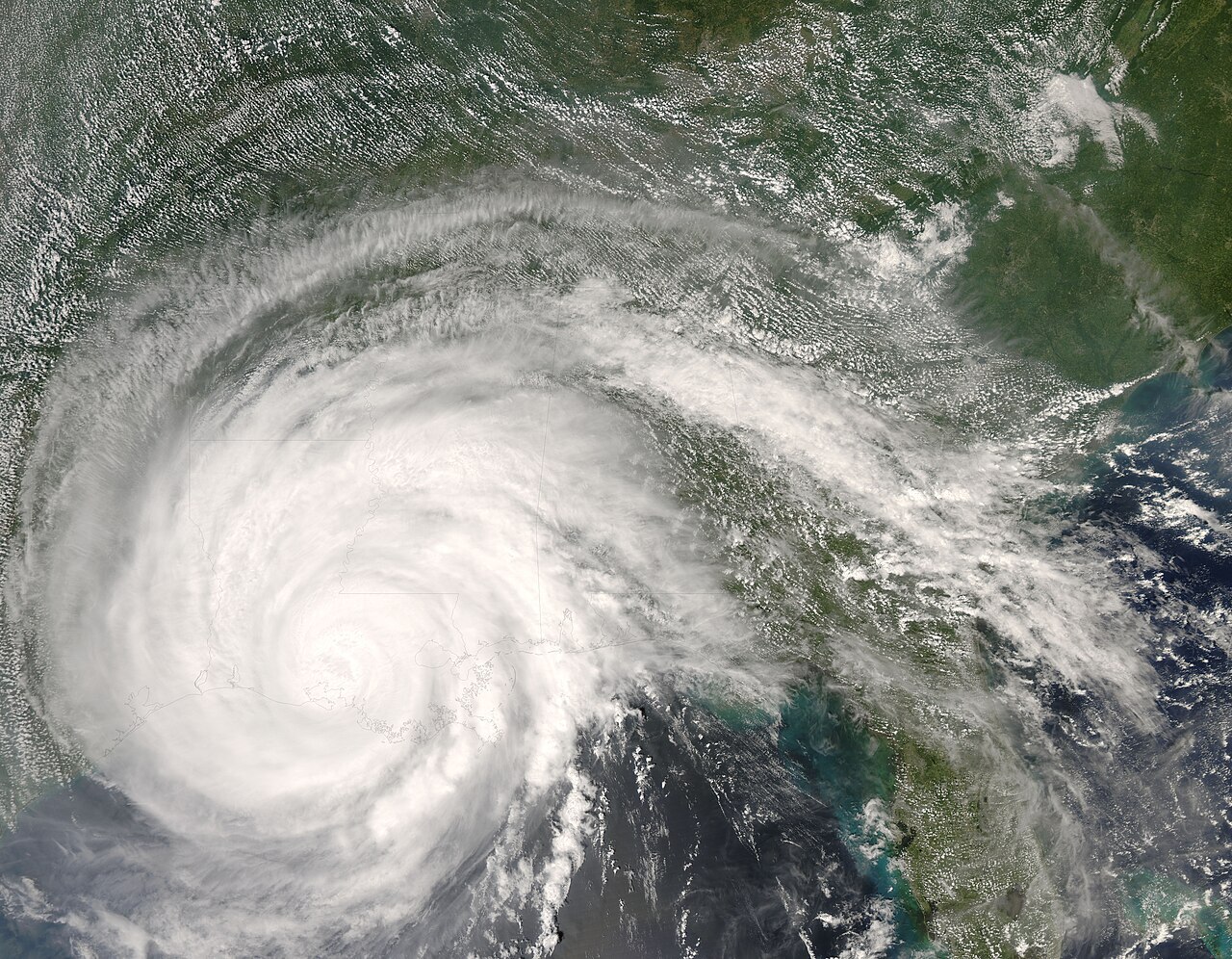
After moving away from Cuba, Gustav made a beeline for the Louisiana coast. Over the Gulf of Mexico, Gustav weakened to a category 2 hurricane as it barreled toward Louisiana. It made landfall south of Houma, Louisiana on the morning of September 1. Damage in central and southern Louisiana was extensive, with major wind and flooding damage commonplace. The hurricane produced extreme rainfall up to 20" in central Louisiana and several tornadoes on its eastern flank.
It was now early September, and national media attention switched to coverage of the Republican National Convention. As Gustav headed inland, it was expected to bring heavy rain over Missouri. Forecast rainfall amounts over parts of Missouri were above 6", mostly over the southeastern side of the state. Preparations were taken in flood-prone communities to prevent the worst.
Rain began falling in Missouri on the evening of September 3, and it would not stop raining in some parts of the state until the early morning hours of September 5. Overall, most of Missouri received 2-4" from Gustav, with the focal point being over central and southern Missouri. Some of the higher rainfall totals of over 6" came from the southern suburbs of Springfield, and over the eastern Ozarks. Despite the heavy rainfall, flooding was somewhat limited in Missouri thanks to preparations. Still, flooding did occur on the local waterways in southern Missouri. Gustav would pave the way for Hurricane Ike to become much more significant when it crossed over Missouri 10 days later.
HURRICANE IKE
Hurricane Gustav was just the second phase of an incredible burst of tropical activity from late August into early September 2008. Before Gustav, Hurricane Fay impacted the Caribbean, then hit the southeast US a week before Gustav. As Gustav impacted Louisiana, Hurricane Hanna was ravaging the northern side of Haiti. Tragically, over 500 people died in Haiti as a result of the flooding caused by Hurricane Hanna. After hitting Haiti, Hanna would strike the Carolina coast as a weak hurricane.
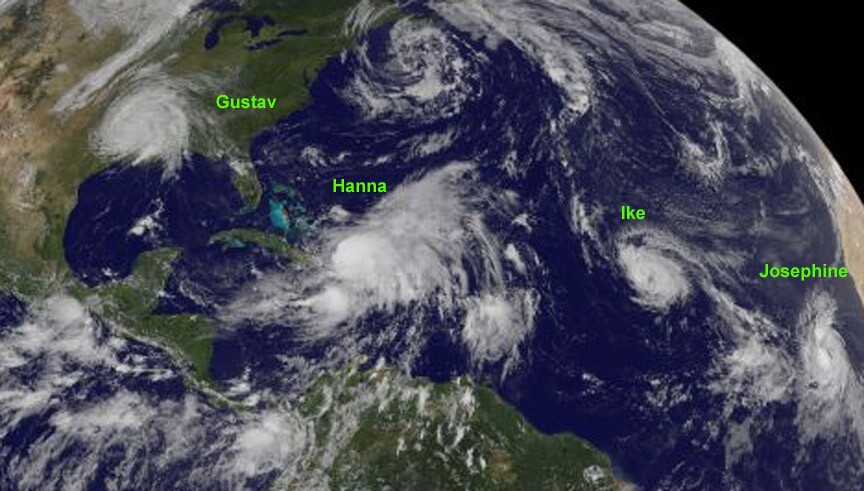
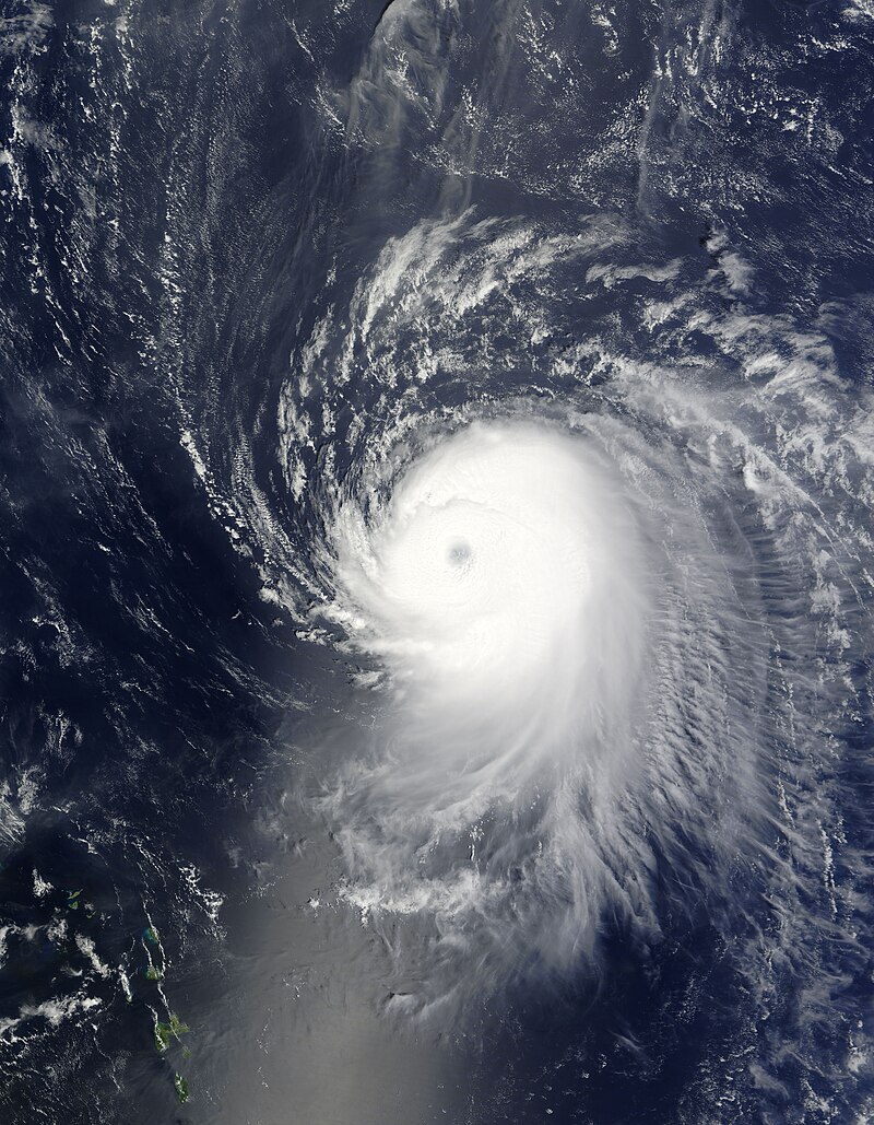
As all this was unfolding, another tropical system began moving over the open waters of the Atlantic. By September 2, the system was named Tropical Storm Ike. On September 3, Ike exploded in intensity. That morning, Ike was just a tropical storm, but by night, it was a major Category 4 hurricane. Ike continued westward as a major hurricane, passing on the north side of Haiti. For Haiti, it was the 5th consecutive storm to impact the country, where another 74 people were killed. Ike made its first landfall in the Bahamas, then into eastern Cuba as a category 4 hurricane. This was the second category 4 to make landfall in Cuba within two weeks, 7 people died in Cuba as a result of the storm.
Now in the Gulf of Mexico, interaction with the hilly terrain of Cuba weakened Ike as it bounded toward Texas. It would never strengthen past a category 2 before landfall. It did grow in size, meaning the effects of prolonged wind and heavy rain would be felt across the Texas and Louisiana coast. Ike made landfall in Galveston, Texas on September 13 as a category 2 hurricane. Galveston was flooded, and Houston suffered wind damage from the hurricane. Ike killed 85 people in Texas alone, but it was not done yet.
Ike maintained some intensity as it zipped inland. High winds came with the system, causing problems from Arkansas to the Great Lakes. Over 200k people were knocked out of power in Arkansas, the largest outage since an ice storm in 2000. Outside of Nashville, TN, two people were killed when a tree fell onto them at a golf course. Louisville, KY saw over 300k without power, the largest in the city's history. The airport was closed for a time, and tree damage was widespread across the city. Widespread wind damage also occurred in Indiana, Ohio, and Pennsylvania. At one point, over 2 million people in Cincinnati, OH were without power. Damage from just the high wind alone was in the billions of dollars. Total outages in the Midwest totaled 3.7 million, one of the largest power outages in Midwest history.

As for Missouri, most effects were not from wind, but heavy rain. Forecasts in Missouri called for 3-7" of rain across the state, on top of the 3-6" that fell from Gustav. The result was widespread flooding across the state, particularly in the St. Louis metro area. Flooding occurred in many spots, but the community of Ladue was hit particularly hard, where 6 people were reduced from their homes due to the rising floodwaters. Other cities also had water rescues and evacuations due to the rain. In total, the St. Louis metro received upwards of 6" of rain from the storm. The wind was also an issue, knocking out power to over 30k people in the city. One woman was killed when lightning struck a tree, which fell on her. Flooding continued for several days afterward.

Across the rest of Missouri, flooding continued in many low-lying areas and creeks. Overall, it was one of the more widespread floods the Show-Me state has dealt with in recent memory. Most of the state received 4-7" of rain from Ike, which combined with the 3-6" from Gustav meant some spots in Missouri picked up over a foot of rain within two weeks. It took many days for the water to recede across the state.

When combined, the damage caused by Hurricanes Gustav and Ike in the United States was unprecedented. Ike became one of the costliest storms in US history, being surpassed by recent storms. The story of Hurricanes Gustav and Ike exemplifies that you do not need to live on the coast to be affected by hurricanes.
