


The transition from summer to fall comes with a variety of things: Cooler weather, changing leaves, the smell of pumpkins and apples, etc. However, as we all know very well in the Midwest, that seasonal transition does not come easy. Case in point, in 1986 the last day of summer for eastern Nebraska and western Iowa came with severe weather as several thunderstorms producing swaths of large hail and damaging winds swept through. In this installment of This Week in Weather History, the hail-ridden end to summer 1986 is looked at.
THE SEVERE WEATHER SET-UP
The severe weather set-up that morning was fairly standard. Weather maps on the morning of September 22 showed a cold front bisecting the viewing area from southwest to northeast. Temperatures were in the low-60s, with dew point values also in the low-60s, conditions favorable for severe weather. Forecasts called for thunderstorms over eastern Nebraska and western Iowa that day.
Thunderstorms began to develop along the stalled out front around 9 am over central Nebraska. Besides some small hail, these storms were not quite severe. At 9:50 am, the first Severe Thunderstorm Warning was issued for Butler County. This would be the main storm of the day as it roughly followed Nebraska Highway 92 eastward toward Omaha. At 10:54 am, a Severe Thunderstorm Warning was extended into Omaha for the storm producing 3" hail over Saunders County. This storm moved over the Omaha metro around 11 am, producing hail, gusty winds, and street flooding.

By early afternoon, another severe thunderstorm passed over Omaha, producing smaller hail and gusty winds. At 2:44 pm, a Severe Thunderstorm Warning was issued for Richardson County in far southeast Nebraska for a storm heading for Falls City. This storm would do major damage in and around Falls City through the early afternoon of September 22nd.
THE FIRST STORM: BUTLER COUNTY TO OMAHA
As the storm intensified over Butler County, it started dropping big hail alongside strong winds. Hail upwards of 3" fell in Butler County into Saunders County. Southeast of David City, damage to farm fields was extensive with many places beaten up by the hail. Windows were blown out, and cars were totaled over much of eastern Butler County. In Saunders County, dozens of farmsteads had varying degrees of damage from dents in cars, to home windows broken. In areas where the winds were strong, sheds were ripped up, and grain bins were destroyed.
As the storm entered Douglas County, 1-2" hailstones fell over western Douglas County. Damage to homes and vehicles in Waterloo, Elkhorn, and West Omaha was not uncommon. Some estimates claim that dozens of homes in western Douglas County were damaged. As the storm continued into Omaha proper, the hail size reduced so the damage was minimal.
However, as the hail size started to shrink farther into Omaha, the intensity of the hail fall increased. West Omaha was hit hard, where in some spots 6" of hail, on top of 1-3" of rainfall, accumulated on roads creating traffic jams. The hail jammed drainage systems, and the result was street flooding. It got so bad at certain intersections of west Omaha that snow removal crews were deployed to shovel away the hail. One of the hardest hit intersections was 105th and Pacific, where it took several hours to clear away the hail and traffic began flowing smoothly.
THE SECOND STORM: FALLS CITY
As Omaha cleaned up from the hail, the storms shifted southward. The second big storm developed near Pawnee City and moved east into Richardson County. Residents of Falls City watched the sky become black as hail up to 4" fell in some parts of town. Across Richardson County, hail damage was done to cars and homes, much like in Butler and Saunders Counties.

In Falls City, the hail was combined with incredibly high winds, perhaps as high as 100 mph. This created extensive damage across Falls City and surrounding areas. The city park was "virtually destroyed" as trees were snapped, fences ripped up, buildings destroyed, and more. The wind was so high in spots that metal was wrapped around trees and power poles.

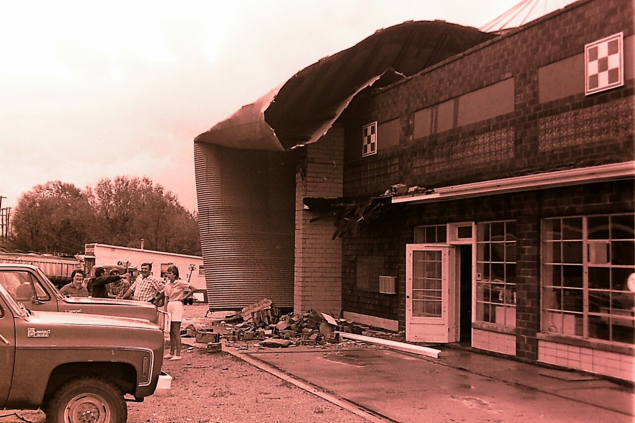
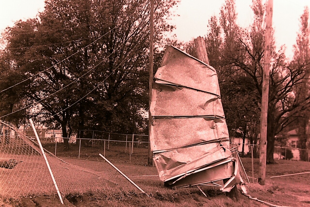
Although the wind was high, it was determined that it was not a tornado in Falls City. The crucial distinguishing factor is straight-line winds versus rotating winds, as 100 mph winds from a storm or a tornado will do similar damage. There was no evidence in Falls City of any cyclonic rotation as determined by the National Weather Service, thus it was determined that the winds were caused by a microburst.

Still, this was one of the worst storms to impact Falls City in recent memory, and it took weeks to months to clean up the damage and rebuild.
